New River Gorge Bridge
USA /
West Virginia /
Fayetteville /
World
/ USA
/ West Virginia
/ Fayetteville
World / United States / West Virginia
NRHP - National Register of Historic Places, road bridge, 1977_construction, arch bridge

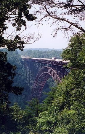
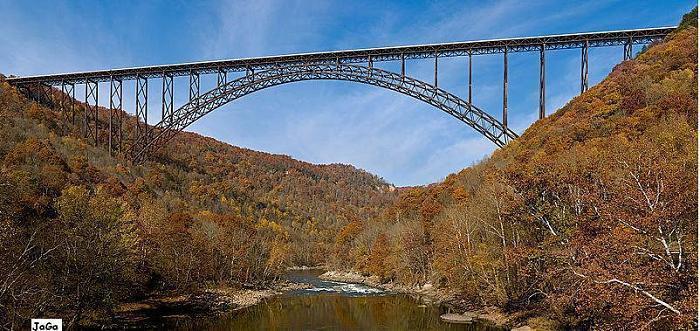

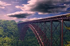
The New River Gorge Bridge is a 3,030' long steel deck arch bridge between Fayetteville and Lansing, West Virginia near South Fayette or Fayette Station. It carries U.S. Route 19 over the New River, County Route 82 (Fayette Station Road) three times, and two lines of CSX railway. It has the seventh-longest arch span in the world at 1700' long and the longest outside of China. It is also among the highest vehicular bridges in the world at 876' above the New River and is the third highest in the United States. The bridge has 9 approach spans, plus the central arch. The deck structure is cast-in-place concrete.
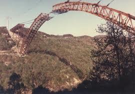
The bridge was constructed from 1974 to 1977, completing Appalachian Development Highway Corridor H. It was the world's highest roadway bridge until 2001, and the world's longest arch span until 2003. In 2013, the bridge was listed on the National Register of Historic Places.
The bridge is a tourist attraction and a major landmark for West Virginia. The bridge is a focal point within the New River Gorge National Park and Preserve. It was featured on the West Virginia state quarter in 2005. Fayette County holds the Bridge Day festival on the third Saturday of October. ( en.wikipedia.org/wiki/Bridge_Day & officialbridgeday.com/ )
Wikipedia article: http://en.wikipedia.org/wiki/New_River_Gorge_Bridge
Nearby cities:
Coordinates: 38°4'7"N 81°4'58"W
This article is protected.
- Fire Captain Fred Burroughs Memorial Bridge 32 km
- Phill G. McDonald Memorial Bridge 33 km
- William C. Brown Bridge 34 km
- Hinton New River Bridge 47 km
- C.H. Charlton Bridge (south) 65 km
- C.H. Charlton Bridge (north) 65 km
- Frank S. Easley Bridge 91 km
- Interstate 77 Bridge over New River 134 km
- U.S. Route 360 South Bridge over the Dan River 247 km
- U.S. Route 360 North Bridge over the Dan River 247 km
- New River Gorge National Park (Lower Gorge unit) 0.6 km
- Fayette County, West Virginia 3.4 km
- Babcock State Park 13 km
- Gauley River National Recreation Area 17 km
- New River Gorge National Preserve 25 km
- Coal Mine 30 km
- Nicholas County, West Virginia 35 km
- Clay County, West Virginia 44 km
- Kanawha County, West Virginia 48 km
- Greenbrier County, West Virginia 58 km
New River Gorge National Park (Lower Gorge unit)
Fayette County, West Virginia
Babcock State Park
Gauley River National Recreation Area
New River Gorge National Preserve
Coal Mine
Nicholas County, West Virginia
Clay County, West Virginia
Kanawha County, West Virginia
Greenbrier County, West Virginia
Comments