Raikoke Island
Russia /
Sahalin /
Severo-Kurilsk /
World
/ Russia
/ Sahalin
/ Severo-Kurilsk
, 399 km from center (Северо-Курильск)
World
island, volcano


Raikoke, also spelled Raykoke, is an uninhabited volcanic island.
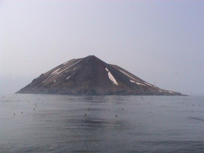
Raikoke is roughly circular, with a length of 2.5 kilometres (1.6 mi) with a width of 2.0 kilometres (1.2 mi), and an area of 4.6 square kilometres (1.8 sq mi). The island is a stratovolcano which rises above a submarine terrace with a depth of 130 metres to a maximum height of 551 metres (1,808 ft) above sea level. The steep-walled crater is 700 metres wide and 200 meters deep, and lava flows extend along the eastern half of the island. The volcano erupted explosively in 1778, destroying the upper third of the island. The volcano remains active, erupting strongly in 1924 and again in 2019.
Raikoke is roughly circular, with a length of 2.5 kilometres (1.6 mi) with a width of 2.0 kilometres (1.2 mi), and an area of 4.6 square kilometres (1.8 sq mi). The island is a stratovolcano which rises above a submarine terrace with a depth of 130 metres to a maximum height of 551 metres (1,808 ft) above sea level. The steep-walled crater is 700 metres wide and 200 meters deep, and lava flows extend along the eastern half of the island. The volcano erupted explosively in 1778, destroying the upper third of the island. The volcano remains active, erupting strongly in 1924 and again in 2019.
Wikipedia article: http://en.wikipedia.org/wiki/Raikoke
Nearby cities:
Coordinates: 48°17'30"N 153°15'3"E
- Matua 20 km
- Rasshua 58 km
- Shiashkotan 86 km
- Ketoy Island 120 km
- Simushir Island 170 km
- Chirpoy 267 km
- Urup Island 371 km
- Iturup 573 km
- Shikotan Island 710 km
- Polonskogo Island 747 km
- Sarychev Peak 23 km
- Krusenstern Strait 26 km
- Ushishir Islands 91 km
- Rikorda Strait 106 km
- Severgin Strait 112 km
- Diany Strait 135 km
- Brouton Bay 150 km
- Prevo Peak 166 km
- Kuril-Kamchatka Trench 179 km
- Zavaritski Caldera 181 km