Fajã Grande
Portugal /
Acores /
Ribeira Grande /
World
/ Portugal
/ Acores
/ Ribeira Grande
World / Portugal / Azores / Lajes das Flores
village, interesting place

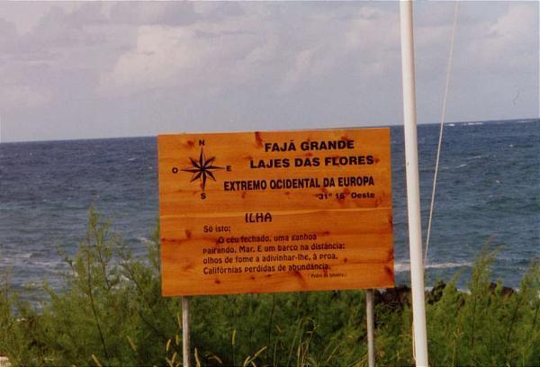
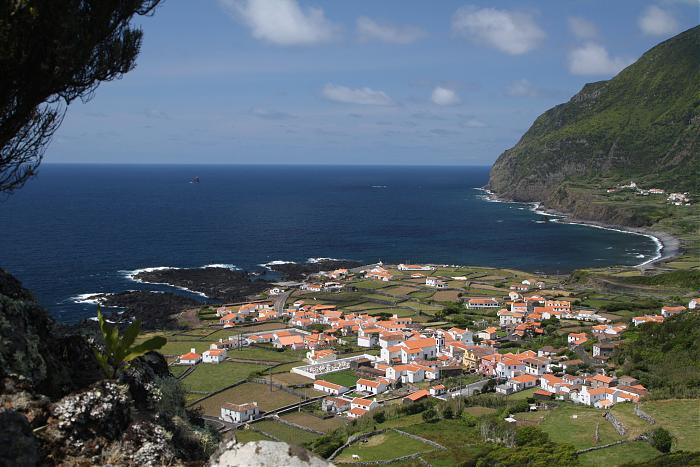
Fajã Grande is a rural civil parish in the municipality of Lajes das Flores in the Portuguese archipelago of the Azores. The population in 2011 was 202, in an area of 12.97 km². Although it is a relatively small population, it is one of the largest centers in the municipality of Lajes das Flores, about 17 kilometres (11 mi) from the municipal seat, and the westernmost settlement in Europe. It contains the localities Cuada, Ponta (da Fajã) and Fajã. Landslides around the area of Ponta da Fajã in 1987 resulted in the declaration of this zone as high risk resulting in the express prohibition of new buildings and future remodeling of existing homes. Further landslides around Covas, in 1991, resulted in new laws to restrict residents in the area, which was ignored by the 20 inhabitants, who have maintained existing buildings .The village is located in an extensive fajã (a small area of flat fertile land at the bottom of a seaside cliff composed of volcanic and geomorphological debris) on the western coast and delimited by the Rocha da Fajã escarpment (that extends from the northwest to southeast border) and the Ribeira Grande river along the south.
Wikipedia article: http://en.wikipedia.org/wiki/Fajã_Grande
Nearby cities:
Coordinates: 39°27'38"N 31°14'0"W
- Poço do Bacalhau Waterfall 1.9 km
- Old Capelinhos Lighthouse 229 km
- Fort of Porto Pim 248 km
- Observatory 248 km
- Sea Gate Porto-Pim 248 km
- Castelo de Santa Cruz 248 km
- Mount Pico 266 km
- Monte Brazil 357 km
- Campo de São Francisco 520 km
- "Atlantis" or Bathymetric Data 982 km
- Aldeia Da Cuada 3 km
- Flores Island (Azores) 3.5 km
- Ponta Delgada (Santa Cruz das Flores) 5 km
- Runway 18/36 8.8 km
- Flores Airport 8.8 km
- Hotel Ocidental 9 km
- Corvo Airport 26 km
- Runway 12/30 26 km
- Corvo Island 29 km
- Mont Grosso 30 km