Point Conception Lighthouse
USA /
California /
Lompoc /
World
/ USA
/ California
/ Lompoc
World / United States / California
lighthouse, NRHP - National Register of Historic Places, historic landmark
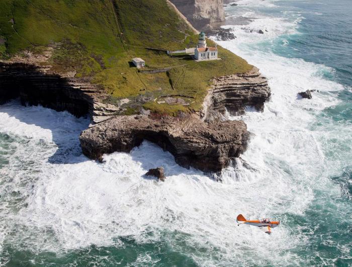


The light was lit on 1 February 1856, making it the sixth lighthouse in the state of California; however, the building standing here today dates to 1881. Due to its location within the Bixby Ranch property, the lighthouse remains isolated and nearly pristine. The light was automated by the US Coast Guard, its last caretaker, in 1973.
www.lighthousefriends.com/light.asp?ID=11
www.nps.gov/history/Maritime/light/ptconc.htm
www.uslhs.org/national_archives/point_conception.htm
www.edhat.com/mobile/news.cfm?id=106961
www.lighthousefriends.com/light.asp?ID=11
www.nps.gov/history/Maritime/light/ptconc.htm
www.uslhs.org/national_archives/point_conception.htm
www.edhat.com/mobile/news.cfm?id=106961
Wikipedia article: http://en.wikipedia.org/wiki/Point_Conception_Light
Nearby cities:
Coordinates: 34°26'55"N 120°28'14"W
- Santa Cruz (Gull Island) Aid to Navigation 81 km
- Lantern Point 303 km
- Beacon Hill 1108 km
- Heceta Head Lighthouse, Devils Elbow State Park 1124 km
- Merry Island 1696 km
- Lake Minatare State Recreation Area and Historic Lake Minatare Lighthouse 1697 km
- Playa de la Isla de la Piedra 1854 km
- Smoky Point Lighthouse 3781 km
- USCG Molokai Light 3857 km
- USCG La’au Point 3894 km
- Unocal Government Point Production Facilities (site) 1.4 km
- Cojo Bay 3 km
- Cojo-Jalama Ranch 4.3 km
- Rancho La Espada 12 km
- Hollister Ranch 15 km
- Mount Tranquillon 17 km
- Celite Corporation Diatomite Quarry 18 km
- Gaviota State Park 23 km
- Vandenberg Air Force Base (VBG/KVBG) 30 km
- Los Padres National Forest 85 km