Binmaley
Philippines /
Ilocos /
Naguilayan /
World
/ Philippines
/ Ilocos
/ Naguilayan
World / Philippines / Pangasinan / Binmaley
town, municipality, third-level administrative division
Municipality of Binmaley, Province of Pangasinan
Land Area: 118.50 km²
ZIP Code: 2417
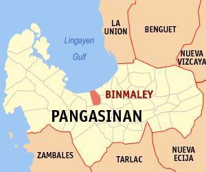
Binmaley is a coastal municipality in the province of Pangasinan in the Philippines. As of the 2010 Census, it had a population of 78,702 people.
The town is located along the central coastland of Pangasinan facing the South China sea, situated in between Lingayen and Dagupan City.
On January 8-9, 1945, the amphibious forces of U.S. General Douglas MacArthur used the town's beach, designated as "yellow beach", alongside the beaches of Lingayen, Dagupan, and San Fabian, in their landing operations to liberate Luzon from Japanese occupation during World War II.
Binmaley is politically subdivided into 33 barangays:
-Amancoro
-Balagan
-Balogo
-Basing
-Baybay Lopez
-Baybay Polong
-Biec
-Buenlag
-Calit
-Caloocan Dupo
-Caloocan Norte
-Caloocan Sur
-Camaley
-Canaoalan
-Dulag
-Gayaman
-Linoc
-Lomboy
-Nagpalangan
-Malindong
-Manat
-Naguilayan
-Pallas
-Papagueyan
-Parayao
-Poblacion
-Pototan
-Sabangan
-Salapingao
-San Isidro Norte
-San Isidro Sur
-Santa Rosa
-Tombor
Pangasinan Webpage: www.pangasinan.org/binmaley/
Land Area: 118.50 km²
ZIP Code: 2417
Binmaley is a coastal municipality in the province of Pangasinan in the Philippines. As of the 2010 Census, it had a population of 78,702 people.
The town is located along the central coastland of Pangasinan facing the South China sea, situated in between Lingayen and Dagupan City.
On January 8-9, 1945, the amphibious forces of U.S. General Douglas MacArthur used the town's beach, designated as "yellow beach", alongside the beaches of Lingayen, Dagupan, and San Fabian, in their landing operations to liberate Luzon from Japanese occupation during World War II.
Binmaley is politically subdivided into 33 barangays:
-Amancoro
-Balagan
-Balogo
-Basing
-Baybay Lopez
-Baybay Polong
-Biec
-Buenlag
-Calit
-Caloocan Dupo
-Caloocan Norte
-Caloocan Sur
-Camaley
-Canaoalan
-Dulag
-Gayaman
-Linoc
-Lomboy
-Nagpalangan
-Malindong
-Manat
-Naguilayan
-Pallas
-Papagueyan
-Parayao
-Poblacion
-Pototan
-Sabangan
-Salapingao
-San Isidro Norte
-San Isidro Sur
-Santa Rosa
-Tombor
Pangasinan Webpage: www.pangasinan.org/binmaley/
Wikipedia article: http://en.wikipedia.org/wiki/Binmaley,_Pangasinan
Nearby cities:
Coordinates: 16°0'10"N 120°17'15"E
- Mangatarem 20 km
- Santa Cruz 47 km
- Mabini 49 km
- Candelaria 52 km
- San Jose 53 km
- Capas 64 km
- Bokod 78 km
- Botolan 79 km
- Kayapa 85 km
- Subic 112 km
- Naguilayan Elementary School 0.3 km
- Camaley Central School 0.8 km
- Fishpond 4 "Busilak" Leticia Ferrer 3.6 km
- B. Martin Macaltao bubon and riceland 3.9 km
- Pallas-Papagueyan Elementary School 3.9 km
- Fishpond 2 "Loreng" Leticia Ferrer 4 km
- kuya Santie's fishpond 1.4 hectars 4.1 km
- Parayao National High School 4.1 km
- Malawa 5.4 km
- Pangasinan 6 km
Comments