Kaliganj Upazila HQ
Bangladesh /
Jhanaydah /
Kaliganj /
World
/ Bangladesh
/ Jhanaydah
/ Kaliganj
World / Bangladesh / Khulna / Jessore / Jhenaidah
archaeological site, township, fourth-level administrative division, local government
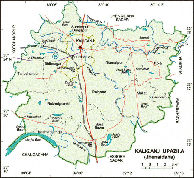
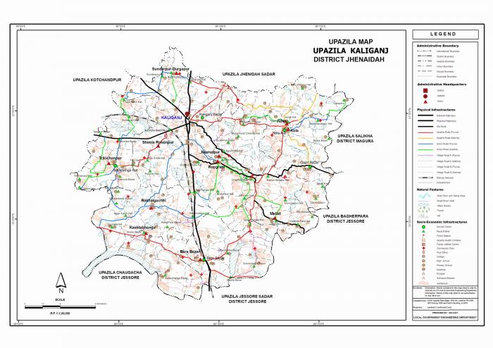
Kaliganj Upazila (Jhenaidah district) with an area of 303.53 sq km, is bounded by Jhenaidah sadar upazila on the north, Jessore sadar and Chaugachha upazilas on the south, Salikha and Bagherpara upazilas on the east, Kotchandpur and Chugachha upazila on the west. Main rivers are Chitra, Bhairab, Begabati. Main baors (depressions) are Morjat, Sarjat, Sako, Barfa and Simla Baor. Noted beels are Uttar (Magura-Tattipur), Dighar, Arua Salva and Tentul Beel.
The location of Kaliganj town is 23.4084332N 89.1359725E. Kaliganj (Town) a municipal town, consists of 9 wards and 20 mahallas. The area of the town is 16.49 sq km. The town has a population of 36779, male 53.51% and female 46.49%; population density per sq km is 2230. Literacy rate among the town people is 43.9%.
Kaliganj thana was established in 1863 and was turned into an upazila in 1983. The upazila consists of one municipality, 9 wards, 11 union parishads, 188 mouzas and 214 villages.
Archaeological heritage and relics: Banyan tree (250 years old) at Bethuli (Shuitala) 6 km on the east of Kaliganj upazila sadar. This tree is known to be the biggest banyan tree in Asia. Many archaeological relics of the Sultanate period have been discovered at Barobazar of this upazila. These include Ghorar Mosque; Jore Bangla Mosque, Jore Bangla Dighi (ninth century AH); Galakata Mosque; Monohar Mosque; Nungola Mosque; Pir Pukur Mosque; Cheragdani Mosque; 36 domed Satgachhia Mosque; Shukkur Mallick Mosque; Badedihi Mosque. Besides, Ghoper Dhibi and Ghazir Dhibi are notable. Ancient dighis (ponds) include Rajmatar Dighi, Sawdagar Dighi, Pir Pukur, Mirer Pukur, Ghoramari Pukur, Cheragdani Pukur, Panch Pir Dighi, Jal Dhala Dighi and Sreeram Raja Dighi. On the south bank of the Sreeram Raja Dighi there exist graves of Gazi, Kalu and Champabati side by side.
As of the 1991 Bangladesh census, Population 219126; male 51.76%, female 48.24%; Muslim 81.46%, Hindu 18.25%, Buddhist 0.02% and Christian 0.27%.
Religious institutions: Mosque 288, temple 75 and church 4.
Literacy and educational institutions: Average literacy 29.7%; male 31.1% and female 21.6%. Educational institutions: college 4, secondary school 40, madrasa 10, government primary school 66, non-government primary school 66, low cost primary school 6 and satellite primary school 6. Noted educational institutions: Naldanga Bhusan Pilot High School (1882), Barobazar High School (1937), Kaliganj Government Primary School (1905), Raigram Banikanta Secondary School (1920), Mahtab Uddin Degree College, Panch Kahunia High School, Kola High School.
Cultural organisations: Club 1, social and cultural organisations 29, orphanage 3, cinema hall 3 and women's society 1.
Main occupations: Agriculture 42.78%, agricultural labourer 24.64%, wage labourer 3.08%, industry 1.39%, transport 2.87%, commerce 12.28%, service 5.79% and others 7.17%.
Land use: Total land 30354.76 hectares; single crop 14%, double crop 56% and treble crop land 30%; cultivable land under irrigation 51%.
Land control: Among the peasants 19% are landless, 49% small, 26% intermediate and 6% rich; cultivable land per head 0.11 hectare.
Main crops: Paddy, jute, wheat, betel leaf, mustard seed, sesame, brinjal, onion, garlic and vegetables.
Fisheries, dairies, poultries Fishery 35, poultry 44, dairy 24.
Communication facilities- Roads: pucca 62 km, semi pucca 50 km, mud road 430 km; railways 16 km; waterways 8 nautical miles.
Manufactories: Sugar mill 1, textile mill 2 (extinct), ice factory 7, rice mill 30, oil mill 5, flour mill 1, dal (pulse) mill 3, saw mill 30, welding 25.
Cottage industries: Weaving 400, bamboo and cane work 323, goldsmith 110, blacksmith 85, potteries 55, wood work 90 and wheel making (bullock cart) 24.
NGO activities: Operationally important NGOs are brac, asa, grameen bank, CSS, Srejani, Welfare, Paradise, Unnayan Dhara and Atma Biswas.
Health centres: Upazila health complex 1, union health & family welfare centre 8, satellite clinic 2 and veterinary hospital 1.
Nearby cities:
Coordinates: 23°24'19"N 89°8'24"E
- Abhaynagar Upazila HQ 45 km
- Fakirhat Upazila HQ 87 km
- Kachua Upazila HQ 109 km
- Koyra Upzila HQ 114 km
- Sarishabari Upazila 170 km
- Bholahat Upazila HQ 198 km
- Gobindaganj Upazila 204 km
- Shaghatta Upazila 207 km
- Maidi Vdc 668 km
- Samote Union Council 1894 km
- ullah, kaligonj, jhenidah 7.6 km
- Historical 12 Aolia (saint) 11 Ponds and 10 Masjid's 11 km
- BAMONYLE 14 km
- long lake 14 km
- BAMONYLE 14 km
- BAMONYLE 14 km
- Jhenaidah District Town 16 km
- Chuadanga District 39 km
- Khulna Division 59 km
- TROPIC OF CANCER 843 km
Comments