Mitchel Air Force Base - Runways (East Garden City, New York)
USA /
New York /
Uniondale /
East Garden City, New York
World
/ USA
/ New York
/ Uniondale
World / United States / New York
military, runway, place with historical importance, historical layer / disappeared object
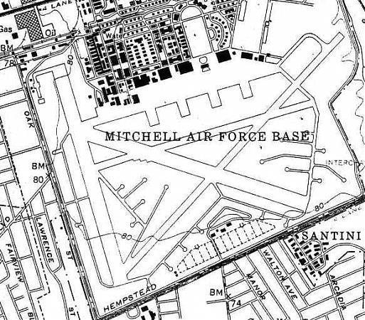
This is a visual depiction of the runways at Mitchel Air Force base, which incorporates remnant pieces of actual runway where they still exist. The most prominent pieces shown are those of runway 5/23 (in the upper righthand corner of the picture), which ran from the southwest to the northeast and was Mitchel's longest at almost 5,700 feet. In addition to 5/23, Mitchel had an additional three runways, which were between 4,800 and 4,960 feet in length.
The southwest portion of runway 5/23 is currently used for Hofstra University parking. The northwest portion is used by the Nassau County Police Department Training Academy for vehicle obstacle training.
The southwest portion of runway 5/23 is currently used for Hofstra University parking. The northwest portion is used by the Nassau County Police Department Training Academy for vehicle obstacle training.
Nearby cities:
Coordinates: 40°43'24"N 73°35'45"W
- Floyd Bennett Field (NOP) 29 km
- Fort Hancock Historic Core 45 km
- NWS Earle Pier Complex/Leonardo Piers 50 km
- US Naval Weapons Station Earle 53 km
- Fort Monmouth Reuse and Redevelopment Area 60 km
- Munition Rail Transport Storage Area 67 km
- US Naval Weapons Station Earle - Mainside 72 km
- Naval Air Engineering Station - Lakehurst 104 km
- Naval Air Warfare Center (NAWC), Lakehurst, Aircraft Platform Interface Group 104 km
- Fort Dix Military Reservation 117 km
- Nassau Community College 0.8 km
- Hofstra University 0.8 km
- Uniondale, New York 2.3 km
- Eisenhower Park 2.6 km
- White & Blue Courses at Eisenhower Park 2.9 km
- Carle Place, New York 3.2 km
- East Meadow, New York 3.3 km
- Nassau County, New York 3.4 km
- Salisbury, New York 3.8 km
- Town of North Hempstead 10 km