Former Leicester Central railway station (Leicester)
United Kingdom /
England /
Leicester
World
/ United Kingdom
/ England
/ Leicester
World / United Kingdom / England
historical layer / disappeared object
Add category

Date opened: 15.3.1899
Company on opening: Great Central Railway
Date closed to passengers: 5.6.1969
Date closed completely: 1980's (goods yard)
Company on closing: British Rail (London Midland Region)
Present state:
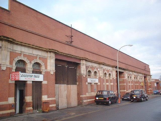
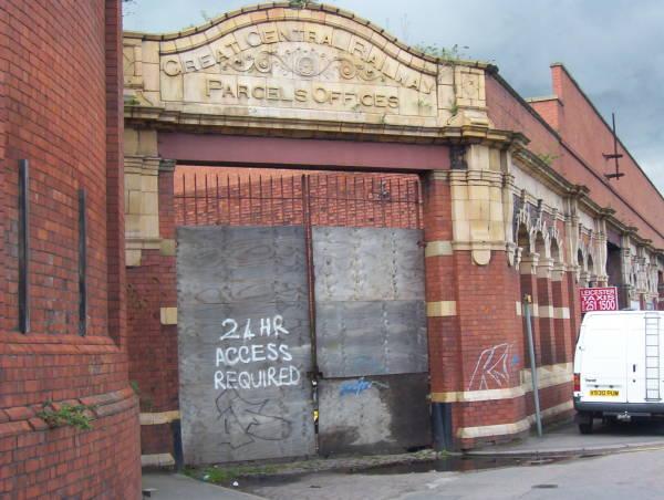
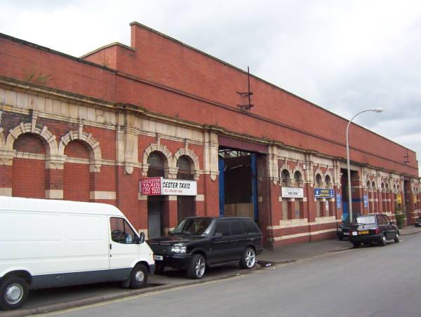
The street level buildings comprising the parcels office, booking hall and covered forecourt and taxi waiting area with original lights and a glass roof are largely intact and there are plans to restore the buildings as part of the regeneration of the waterside area the arches will be made in to shops. The booking office still has its ticket windows and old timetables and signs are still to be seen on the wall. There is a sign above the entrance to the parcels office. Although the platform has been largely demolished two sections of the north end of the platform incorporating the two bays survive as part of the bridge over All Saints Road. The bridge has been retained to provide access to the industrial units at the north of the station site. Within the goods yard the electricity generator and hydraulic power house has been renovated as the Quay pub and the repair shop is now in industrial use, all other buildings, including the loco shed have been demolished and the area redeveloped.
The Great Central Railway was the last major railway line to be built in England. It began at Annesley and run via Nottingham, Leicester and Rugby before terminating at London Marylebone. The railway was built by Edward Watkin, the man who had already constructed the London Metropolitan Underground Line. Watkin was a visionary and planned a Channel Tunnel one hundred years before the 'Chunnel' was finally opened.
The line was built over the site of a Roman tessellated floor that had been found in 1830. However, the railway company took its responsibilities seriously and made the floor available to the public by means of a public access through a special tunnel under the embankment. When the line closed the floor was removed to the Jewry Wall Museum. When the floor was taken up a quantity of Iron Age pottery was found; an indication that there had been a substantial settlement on the site before the Roman occupation.
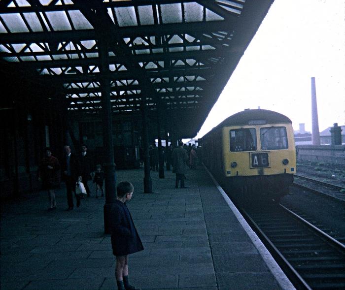
The station, which was built on part of the mile-long viaduct that ran at an average height of about six meters above the level of the streets, closed on 16 May 1969. It is now used mainly by car repair firms.
Company on opening: Great Central Railway
Date closed to passengers: 5.6.1969
Date closed completely: 1980's (goods yard)
Company on closing: British Rail (London Midland Region)
Present state:
The street level buildings comprising the parcels office, booking hall and covered forecourt and taxi waiting area with original lights and a glass roof are largely intact and there are plans to restore the buildings as part of the regeneration of the waterside area the arches will be made in to shops. The booking office still has its ticket windows and old timetables and signs are still to be seen on the wall. There is a sign above the entrance to the parcels office. Although the platform has been largely demolished two sections of the north end of the platform incorporating the two bays survive as part of the bridge over All Saints Road. The bridge has been retained to provide access to the industrial units at the north of the station site. Within the goods yard the electricity generator and hydraulic power house has been renovated as the Quay pub and the repair shop is now in industrial use, all other buildings, including the loco shed have been demolished and the area redeveloped.
The Great Central Railway was the last major railway line to be built in England. It began at Annesley and run via Nottingham, Leicester and Rugby before terminating at London Marylebone. The railway was built by Edward Watkin, the man who had already constructed the London Metropolitan Underground Line. Watkin was a visionary and planned a Channel Tunnel one hundred years before the 'Chunnel' was finally opened.
The line was built over the site of a Roman tessellated floor that had been found in 1830. However, the railway company took its responsibilities seriously and made the floor available to the public by means of a public access through a special tunnel under the embankment. When the line closed the floor was removed to the Jewry Wall Museum. When the floor was taken up a quantity of Iron Age pottery was found; an indication that there had been a substantial settlement on the site before the Roman occupation.
The station, which was built on part of the mile-long viaduct that ran at an average height of about six meters above the level of the streets, closed on 16 May 1969. It is now used mainly by car repair firms.
Wikipedia article: http://en.wikipedia.org/wiki/Leicester_Central_railway_station
Nearby cities:
Coordinates: 52°38'13"N 1°8'29"W
- Former RAF Spanhoe 35 km
- Former RAF Deenethorpe 39 km
- Former RAF Balderton 51 km
- Durobrivae 53 km
- Former RAF Fulbeck 56 km
- Former Cranwell - Sleaford Railway Line 62 km
- Former RAF Skellingthorpe 74 km
- Former RAF Metheringham 77 km
- Former RAF Scofton 78 km
- Former RAF Dunholme Lodge 85 km
- St Nicolas Circle 0.3 km
- Highcross Leicester 0.3 km
- Leicester City Centre 0.8 km
- Bede Island 0.8 km
- De Montfort University Leicester Campus 0.9 km
- Abbey Park 1.1 km
- Frog Island 1.1 km
- St Matthews 1.3 km
- The Junction - St. Georges Retail Park 1.4 km
- Highfields 2.2 km