Former Orroral Valley Tracking Station
Australia /
Australian Capital Territory /
Canberra /
World
/ Australia
/ Australian Capital Territory
/ Canberra
World / Australia / Australian Capital Territory
NASA, satellite/space tracking station


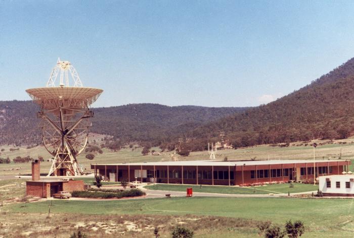
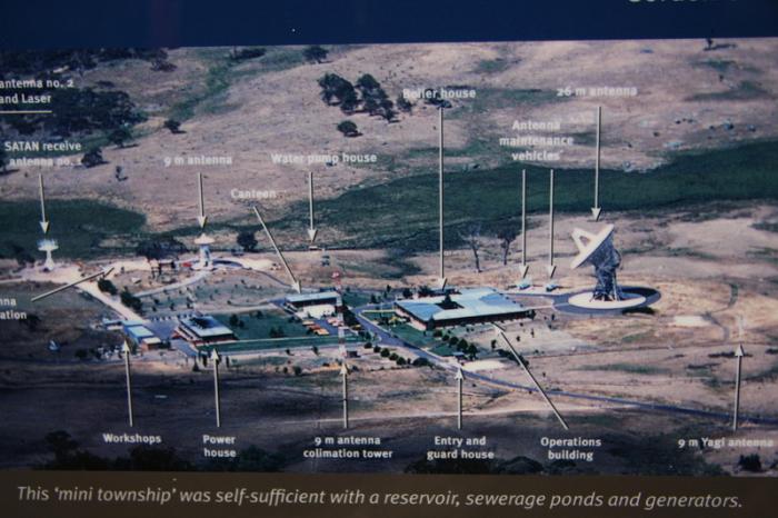
The Orroral Valley Tracking Station was a part of STADAN - the Satellite Tracking and Data Acquisition Network which was run by NASA and was one of only three such locations around the world. The station operated from 1967 until 1981.
honeysucklecreek.net/other_stations/orroral/index.html
The 26 m telescope was moved in 1985 to Tasmania, Australia, and now forms the core of the Mount Pleasant Radio Observatory run by the School of Mathematics and Physics, University of Tasmania.
honeysucklecreek.net/other_stations/orroral/index.html
The 26 m telescope was moved in 1985 to Tasmania, Australia, and now forms the core of the Mount Pleasant Radio Observatory run by the School of Mathematics and Physics, University of Tasmania.
Wikipedia article: http://en.wikipedia.org/wiki/Orroral_Valley_Tracking_Station
Nearby cities:
Coordinates: 35°37'39"S 148°57'20"E
- Former Honeysuckle Creek Tracking Station 5.4 km
- Canberra Deep Space Communication Complex, NASA 26 km
- Island Lagoon Minitrack (site) 1216 km
- Woomera Space Communications Centre (site) 1216 km
- Telemetry and Control Facility 1247 km
- Former Red Lake Tracking Station 1248 km
- Carnarvon Space Tracking Station 3570 km
- Orroral Valley 3.7 km
- Tantangara Reservoir 31 km
- Lake Eucumbene 54 km
- Talbingo Reservoir 57 km
- Blowering Reservoir 65 km
- Lake Jindabyne 87 km
- Bogandyera Mountain 96 km
- Pine Mountain 111 km
- Snowy Mountains 113 km
- Tom Groggin Station 124 km