South Brother Island
India /
Andaman and Nicobar Islands /
Port Blair /
World
/ India
/ Andaman and Nicobar Islands
/ Port Blair
World / India / Andaman and Nicobar / Andaman Islands
island
Add category

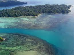
South Brother, an uninhabited island in the Andaman Archipelago.
The polygon follows the high-tide outline as inferred from the vegetation seen on GoogleMaps images. The eastern part of the island was covered by clouds and its outline is totally guessed. CAVEAT: The images apparently were taken before the 2004 earthquake which may have lowered or raised the land by 1 meter or more.
The polygon follows the high-tide outline as inferred from the vegetation seen on GoogleMaps images. The eastern part of the island was covered by clouds and its outline is totally guessed. CAVEAT: The images apparently were taken before the 2004 earthquake which may have lowered or raised the land by 1 meter or more.
Nearby cities:
Coordinates: 10°55'59"N 92°36'47"E
- Little Andaman Island (India) 26 km
- Car Nicobar (India) 187 km
- Teressa Island (India) 292 km
- Kamorta (Camorta) 314 km
- Katchal Island (Nicobar Island - India) 332 km
- Nancowry (Nicobar) 338 km
- Little Nicobar (India) 404 km
- Great Nicobar Island (India) 426 km
- Weh Island 629 km
- Breueh Island 634 km
- North Brother's reef 8.3 km
- Mangrove Swamp, Little Andaman 12 km
- Mangrove Swamp, Little Andaman 30 km
- Hut Bay, Little Andaman 35 km
- West Bay, Little Andaman 42 km
- South Bay 49 km
- The Andaman and Nicobar Islands Territory (India) 109 km
- Ten Degree Channel 117 km
- Sawai Bay 190 km
- Nicobar Islands 336 km