1956 Grand Canyon Disaster
USA /
Arizona /
Grand Canyon Village /
World
/ USA
/ Arizona
/ Grand Canyon Village
World / United States / Arizona
crash site, interesting place, historical layer / disappeared object
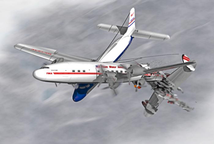
June 30, 1956. United Airlines Flight 718 (Douglas DC-7) collided in mid-air with TWA Flight 2 (Lockheed L-1049 Super Constellation) over this point. As was customary of the day, neither aircraft was under direct radar control. Both aircraft had departed Los Angeles (LAX) only minutes apart. The United flight headed for Chicago, the TWA flight for Kansas City. Total fatalities were 128, there were no survivors. CAB found that the accident was caused by, among other things, lack of adequate ATC coverage in the area, visual limitations, and cockpit management of both flight crews. The accident was the catalyst for major changes in air traffic control procedures still in use today. Due to the remoteness of the location, wreckage of both aircraft can still be seen by rafters in the canyon today.
Wikipedia article: http://en.wikipedia.org/wiki/United_Airlines_Flight_718
Nearby cities:
Coordinates: 36°11'37"N 111°49'16"W
- Potosi Mountain 332 km
- X-15 Rocket Plane Emergency Landing Site, Mud Lake 505 km
- Sunken Harbor 629 km
- Steve Fossett ID found somewhere around here 670 km
- 1974 UFO Crash Site 918 km
- White Hill 980 km
- Wreck of USS Independence (CVL-22) 1016 km
- United Flight 232 Crash Site 1496 km
- 1999 South Dakota Learjet crash 1502 km
- Wreck of USS Nevada (BB-36) 4856 km
- The Grand Canyon (central section) 22 km
- Grand Canyon Village, Arizona 32 km
- The Grand Canyon (north-east section) 43 km
- Kaibab Plateau 49 km
- Powell Plateau 54 km
- Aztec Amphitheatre 56 km
- Great Thumb Mesa 64 km
- Havasupai Indian Reservation 74 km
- The Grand Canyon (west-central section) 84 km
- Grand Canyon National Park 87 km
Comments