Baluarte de San Diego (Manila)
Philippines /
National Capital Region /
Manila
World
/ Philippines
/ National Capital Region
/ Manila
World / Philippines / Metropolitan Manila / Manila
tower, military, place with historical importance, archaeological site, fortification, interesting place, bastion (fortification part)


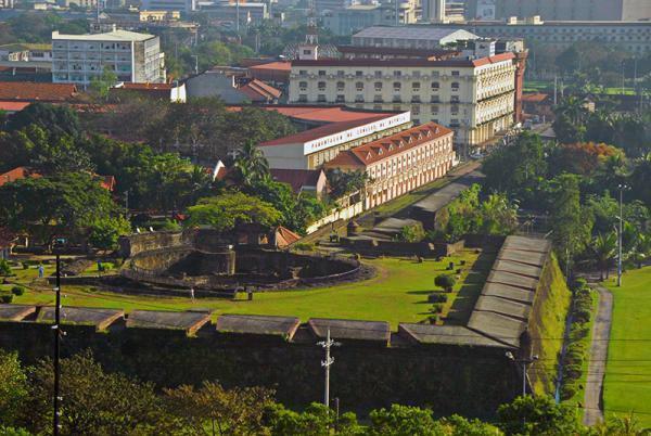

Bastión de San Diego: Named after St. James the Great (aka San Iago, Santiago). Probably built around an older fortification erected by Sedeño in the late 16th century, named Nuestra Señora de Guia (Our Lady of Guidance) after a hermitage and church in Ermita, which it faced.. Presently, the bastion is an archaelogical site where three rings of stone connected by crossways were unearthed. Most opine that one of these rings was Sedeño’s fort. It is known that the fort was integrated into the Bastion between 1591-94 when Gov. Perez de Dasmariñas built the stone perimeter of the City of Manila.
Also known as Barbette San Diego. Shaped like the 'ace of spades' this structure was built by the Spanish and used as a foundry. During WWII it was mostly destroyed. Today, it is walkable as ruins. Photo from PacificWrecks.com.
Also known as Barbette San Diego. Shaped like the 'ace of spades' this structure was built by the Spanish and used as a foundry. During WWII it was mostly destroyed. Today, it is walkable as ruins. Photo from PacificWrecks.com.
Wikipedia article: https://en.wikipedia.org/wiki/Baluarte_de_San_Diego
Nearby cities:
Coordinates: 14°35'7"N 120°58'32"E
- Rizal Park (Luneta) 0.7 km
- Intramuros 1.4 km
- Taguig 5.4 km
- Malibay 5.9 km
- Manila 7.5 km
- Provident Village 13 km
- Manila Memorial Park - Sucat 14 km
- Taal Volcano 60 km
- Watershed Tignoan Real, Quezon 68 km
- Wreck of USS Princeton (CVL-23) 286 km
- Manila Hotel 0.3 km
- Club Intramuros Golf Course 0.4 km
- National Museum Complex 0.7 km
- Ermita 0.8 km
- Manila South Harbor 0.9 km
- Manila Civic Center 1 km
- Port Area 1.3 km
- Quiapo 1.8 km
- Port of Manila 3.1 km
- Manila Bay 21 km
Comments