Noakhali District Town
Bangladesh /
Noakhali /
World
/ Bangladesh
/ Noakhali
/ Noakhali
World / India / Tripura / South Tripura
third-level administrative division, town district
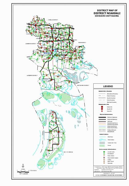


Noakhali District (chittagong division) with an area of 3600.99 sq km, is bounded by comilla district on the north, the Meghna estuary and the bay of bengal on the south, feni and chittagong districts on the east, lakshmipur and bhola districts on the west. Annual average temperature: maximum 34.3°C, minimum 14.4°C; annual rainfall 3302 mm. Main rivers are Bamni and meghna.
Noakhali (Town) Noakhali Sadar upazila town (Maijdi) consists of 9 wards and 36 mahallas. It has an area of 12.61 sq km. The town has a population of 74585; male 51.50%, female 48.50%; population density per sq km 5915. Literacy rate among the town people is 60.7%. The ancient name of Noakhali Sadar was Sudharam. In 1948 when the upazila headquarters were extinct by the erosion of the Meghna River, it was shifted 8 km to the north to its present place at Maijdi. The town has five dakbungalows.
Administration: Noakhali district, whose earlier name was Bhulua, was established in 1821. It was named Noakhali in 1868. It consists of six upazilas, 5 municipalities, 45 wards, 90 mahallas, 83 union parishads, 909 mouzas and 978 villages. The upazilas are noakhali sadar, begumganj, chatkhil, companiganj, hatiya and senbagh; the municipalities are Begumganj (Chawmuhani), Companiganj (Bashurhat), Noakhali Sadar, Chatkhil, Kabirhat (Sadar).
Archaeological heritage and relics: Noakhali Public Library (1895), Bajra Shahi Mosque (1153 AH, Chatkhil), Kali Statue (18th century) at Sirajpur union of Companiganj upazila).
Historical events: The ancient name of Noakhali was Bhulua. Once the agricultural activities of the north-eastern region of Bhulua were seriously affected by floodwater of the river Dakatia flowing from the Tripura hills. To save the situation a canal was excavated in 1660 running from the Dakatia through Ramganj, Sonaimudi and Chaumuhani to divert water flow to the junction of the rivers Meghna and Feni. After excavating this long canal Bhulua was renamed "Noakhali" after "Noa" (new) and "khal" (canal) in 1668.
The people of Noakhali actively took part in Jehad Movement in 1830 and Khilafat Movement in 1920. Mahatma Gandhi visited Noakhali (Begumganj upazila) in 1946 to ease communal riots.
Noakhali district was seriously affected many times by natural disasters like high tidal bore, tornado, flood, cyclone etc since 1790. In 1970 devastating tornado and tidal bore took lives of about 10 lakh people of the district. During the War of Liberation many direct and guerilla encounters were held between the Pak army and the freedom fighters.
Population 2533394; male 49.58%, female 50.42%; Muslim 93.41%, Hindu 6.41% and others 0.18%.
Religious institutions: Mosque 2704, temple 58, church 2, tomb 7 and crematory 1.
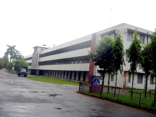
Literacy and educational institutions: Average literacy 37.11%; male 42.9% and female 31.5%. Educational institutions: government college 8, non-government college 23, law college 1, primary training institute 1, government high school 12, non-government high school 229, madrasa 137, government primary school 776, non-government primary school 312, Ansar VDP training centre 1, agricultural training institute 1, police training centre 1, vocational training institute 1, textile training institute 1. Noted educational institutions: Noakhali Zila School (1853), Arun Chandra High School (1914), Brother Andre High School (1857), Ahmadia Model High School (1906), Paura Kalyan High School (1940), Kabir Hat High School (1938), Noakhali Government Girls' High School (1934), Noakhali College (1963), Basur Hat A H C Government High School (1911), Bamni High School (1914, Companiganj Upazila), Basur Hat Islamia Senior Madrasa (1923), Bamni Asiria Senior Madrasa (1915), Begumganj Government Pilot High School (1857), Bajra High School (1919).
Cultural organisations: Club 90, cinema hall 8, public library 14, town hall 1, auditorium 2, literary society 1, theatre group 5, theatre stage 2, women's organisation 2, shilpakala academy 1, shishu academy 1, community centre 3, playground 74.
Main occupations: Agriculture 30.27%, agricultural labourer 16.99%, wage labourer 2.86%, commerce 12.23%, service 19.39%, transport 2.46%, fishing 1.4% and others 14.4%.
Land use: Total cultivable land 229385 hectares, fallow land 17136 hectares.
Land control: Among the peasants 21% are landless, 41% marginal, 21% small, 14% intermediate and 3% rich.
Fisheries, dairies and poultries Dairy 62, poultry 129, fishery 60, hatchery 32, artificial breeding centre 1, government cattle rearing centre 1.
Communication facilities Roads: pucca 804 km, semi pucca 485 km and mud road 2274 km; waterways 30 nautical mile, ferry ghat 1; railways 28 km; rail station 7.
Manufactories: Jute mill, rice mill, flour mill, oil mill, chemical industries, soap factory, printing press, bread and biscuit factory, ice factory, welding, etc.
Cottage industries Weaving, bamboo and cane work, goldsmith, blacksmith, potteries, wood work, brass and bronze work, tailoring, mat work, etc.
NGO activities: Operationally important NGOs are brac, proshika, asa, CARE, nijera kari, Sagarika, Upama, NRDS, Bandan, Hope, etc.
Health centres: Zila sadar hospital 1, TB clinic 1, mission hospital 1, police hospital 1, jail (prison) hospital 1, private hospital and clinic 10, municipal health centre 1, upazila health complex 6, health and family planning centre 75, satellite clinic 6 and maternity and child welfare centre 1.
Noakhali (Town) Noakhali Sadar upazila town (Maijdi) consists of 9 wards and 36 mahallas. It has an area of 12.61 sq km. The town has a population of 74585; male 51.50%, female 48.50%; population density per sq km 5915. Literacy rate among the town people is 60.7%. The ancient name of Noakhali Sadar was Sudharam. In 1948 when the upazila headquarters were extinct by the erosion of the Meghna River, it was shifted 8 km to the north to its present place at Maijdi. The town has five dakbungalows.
Administration: Noakhali district, whose earlier name was Bhulua, was established in 1821. It was named Noakhali in 1868. It consists of six upazilas, 5 municipalities, 45 wards, 90 mahallas, 83 union parishads, 909 mouzas and 978 villages. The upazilas are noakhali sadar, begumganj, chatkhil, companiganj, hatiya and senbagh; the municipalities are Begumganj (Chawmuhani), Companiganj (Bashurhat), Noakhali Sadar, Chatkhil, Kabirhat (Sadar).
Archaeological heritage and relics: Noakhali Public Library (1895), Bajra Shahi Mosque (1153 AH, Chatkhil), Kali Statue (18th century) at Sirajpur union of Companiganj upazila).
Historical events: The ancient name of Noakhali was Bhulua. Once the agricultural activities of the north-eastern region of Bhulua were seriously affected by floodwater of the river Dakatia flowing from the Tripura hills. To save the situation a canal was excavated in 1660 running from the Dakatia through Ramganj, Sonaimudi and Chaumuhani to divert water flow to the junction of the rivers Meghna and Feni. After excavating this long canal Bhulua was renamed "Noakhali" after "Noa" (new) and "khal" (canal) in 1668.
The people of Noakhali actively took part in Jehad Movement in 1830 and Khilafat Movement in 1920. Mahatma Gandhi visited Noakhali (Begumganj upazila) in 1946 to ease communal riots.
Noakhali district was seriously affected many times by natural disasters like high tidal bore, tornado, flood, cyclone etc since 1790. In 1970 devastating tornado and tidal bore took lives of about 10 lakh people of the district. During the War of Liberation many direct and guerilla encounters were held between the Pak army and the freedom fighters.
Population 2533394; male 49.58%, female 50.42%; Muslim 93.41%, Hindu 6.41% and others 0.18%.
Religious institutions: Mosque 2704, temple 58, church 2, tomb 7 and crematory 1.
Literacy and educational institutions: Average literacy 37.11%; male 42.9% and female 31.5%. Educational institutions: government college 8, non-government college 23, law college 1, primary training institute 1, government high school 12, non-government high school 229, madrasa 137, government primary school 776, non-government primary school 312, Ansar VDP training centre 1, agricultural training institute 1, police training centre 1, vocational training institute 1, textile training institute 1. Noted educational institutions: Noakhali Zila School (1853), Arun Chandra High School (1914), Brother Andre High School (1857), Ahmadia Model High School (1906), Paura Kalyan High School (1940), Kabir Hat High School (1938), Noakhali Government Girls' High School (1934), Noakhali College (1963), Basur Hat A H C Government High School (1911), Bamni High School (1914, Companiganj Upazila), Basur Hat Islamia Senior Madrasa (1923), Bamni Asiria Senior Madrasa (1915), Begumganj Government Pilot High School (1857), Bajra High School (1919).
Cultural organisations: Club 90, cinema hall 8, public library 14, town hall 1, auditorium 2, literary society 1, theatre group 5, theatre stage 2, women's organisation 2, shilpakala academy 1, shishu academy 1, community centre 3, playground 74.
Main occupations: Agriculture 30.27%, agricultural labourer 16.99%, wage labourer 2.86%, commerce 12.23%, service 19.39%, transport 2.46%, fishing 1.4% and others 14.4%.
Land use: Total cultivable land 229385 hectares, fallow land 17136 hectares.
Land control: Among the peasants 21% are landless, 41% marginal, 21% small, 14% intermediate and 3% rich.
Fisheries, dairies and poultries Dairy 62, poultry 129, fishery 60, hatchery 32, artificial breeding centre 1, government cattle rearing centre 1.
Communication facilities Roads: pucca 804 km, semi pucca 485 km and mud road 2274 km; waterways 30 nautical mile, ferry ghat 1; railways 28 km; rail station 7.
Manufactories: Jute mill, rice mill, flour mill, oil mill, chemical industries, soap factory, printing press, bread and biscuit factory, ice factory, welding, etc.
Cottage industries Weaving, bamboo and cane work, goldsmith, blacksmith, potteries, wood work, brass and bronze work, tailoring, mat work, etc.
NGO activities: Operationally important NGOs are brac, proshika, asa, CARE, nijera kari, Sagarika, Upama, NRDS, Bandan, Hope, etc.
Health centres: Zila sadar hospital 1, TB clinic 1, mission hospital 1, police hospital 1, jail (prison) hospital 1, private hospital and clinic 10, municipal health centre 1, upazila health complex 6, health and family planning centre 75, satellite clinic 6 and maternity and child welfare centre 1.
Wikipedia article: http://en.wikipedia.org/wiki/Noakhali_District
Nearby cities:
Coordinates: 22°50'43"N 91°5'34"E
- Feni 48 km
- Bhola District Town 54 km
- Khagrachari District 118 km
- Rangamati District 137 km
- Narsingdi District 166 km
- Habigonj District 216 km
- Maulvibazar District 223 km
- Sunamganj District 263 km
- Sylhet District 266 km
- Jiuzhaigou County 1711 km
- Govt. Quarter 2.5 km
- Maizdee Court Housing Area 2.6 km
- Noakhali Police Trainning School 3.1 km
- Police Line, Noakhali. 3.8 km
- Noakhali Science and Technology University, Sonapur, Noakhali-3802. 6 km
- Hapizpur village. Internal place of Gavua 6.3 km
- hat 10 km
- Chondrogonj 14 km
- Lakshmipur District 21 km
- Noakhali District 35 km