San Pedro Hill Air Force Radar Station (Rancho Palos Verdes, California)
USA /
California /
Rancho Palos Verdes /
Rancho Palos Verdes, California
World
/ USA
/ California
/ Rancho Palos Verdes
World / United States / California
military, radar station, military radar
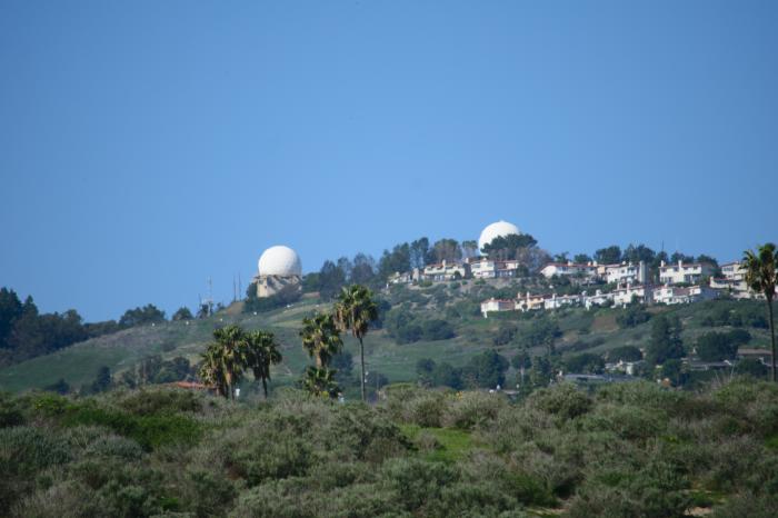
San Pedro Hill, the highest elevation on the Palos Verdes Peninsula.
San Pedro Hill AFS, CA:
The radars included one FAA ARSR-1 search radar; one Air Force AN/FPS-27 search radar; two Army AN/FPS-6 height-finder radars; and two Air Force AN/FPS-6, -6B height-finder radars.
The Air Force AN/FPS-6 (-6A) was subsequently replaced by an AN/FPS-26A height-finder radar, and the AN/FPS-6B was later modified to the AN/FPS-90 variant.
The 670th Radar Squadron (SAGE) was relocated from San Clemente Island AFS, CA (P-39) to man the joint-use radar site at San Pedro Hill AFS.
Wikipedia article: http://en.wikipedia.org/wiki/List_of_radars#Military
Nearby cities:
Coordinates: 33°44'46"N 118°20'11"W
- San Clemente Island 83 km
- Special Warfare Training Area Three (SWAT-3), SCI Underwater Range 84 km
- Naval Air Station Point Mugu 88 km
- Naval Construction Battalion Center (CBC), Port Hueneme 95 km
- Port Hueneme, California 95 km
- San Nicolas Island 126 km
- Vandenberg Air Force Base (VBG/KVBG) 249 km
- Naval Air Station Lemoore 331 km
- Camp Roberts 332 km
- Fort Hunter Liggett 386 km
- Palos Verdes Peninsula 1.5 km
- San Pedro 3.3 km
- Westfield, California 3.7 km
- Walteria 5.9 km
- Valmonte 6.7 km
- Harbor City 6.9 km
- Montemalaga 7.3 km
- Malaga Cove 7.4 km
- South Bay 12 km
- Los Angeles County, California 58 km
Comments