Austin Creek State Recreation Area
USA /
California /
Guerneville /
Armstrong Woods Road, 17000
World
/ USA
/ California
/ Guerneville
World / United States / California
state park
Add category
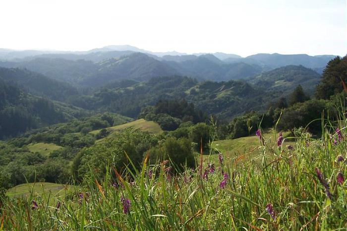
Austin Creek State Recreation Area is adjacent to Armstrong Redwoods State Reserve and is accessed through the same entrance. With open woodlands, rolling hills, and meadows, its topography offers a strong contrast to the dense, primeval redwood forest below. Here you will discover deep tree-lined ravines cooled by year round streams; grassy hillsides burnished golden by the heat of summer sun and turned emerald by plentiful winter rains; oak capped knolls that seem to float like islands on lakes of lowland fog; and rocky mountaintops that offer glimpses of the Pacific ocean. A paradise for the hiker and equestrian, Austin Creek rewards the explorer with twenty miles of trails and panoramic wilderness views, back-country camping, and Bullfrog Pond Campground- accessible by vehicle. The park's rugged topography, with elevations ranging from 150-1500 feet in elevation, offers a sense of isolation from the accustomed sights and sounds of civilization.
MUCH more information at:
www.parks.ca.gov/default.asp?page_id=452
MUCH more information at:
www.parks.ca.gov/default.asp?page_id=452
Wikipedia article: http://en.wikipedia.org/wiki/Austin_Creek_State_Recreation_Area
Nearby cities:
Coordinates: 38°34'0"N 123°2'1"W
- Mount Diablo State Park 116 km
- Sinkyone Wilderness State Park 177 km
- Henry W. Coe State Park 190 km
- Topanga State Park 631 km
- Chino Hills State Park 693 km
- Valley of Fire State Park 775 km
- Antelope Island State Park 960 km
- Golden Gate Canyon State Park 1518 km
- Elephant Butte Lake State Park 1521 km
- Matagorda Island State Park 2679 km
- Armstrong Redwoods State Reserve 3.3 km
- Central Healdsburg 15 km
- Frei Ranch 15 km
- Lake Sonoma 19 km
- Barrelli Creek Vineyard 21 km
- Bald Hills 28 km
- Safari West 29 km
- Knights Valley AVA 30 km
- Geysers Geothermal Field 33 km
- Cobb, California 40 km