CPR Tunnel (Vancouver)
Canada /
British Columbia /
Vancouver
World
/ Canada
/ British Columbia
/ Vancouver
World / Canada / British Columbia / Capital
place with historical importance, historical layer / disappeared object, railway tunnel
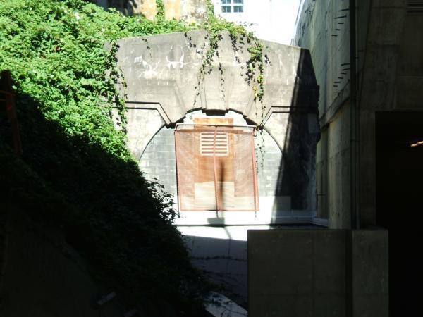
The Canadian Pacific Railway tunnel, Vancouver's oldest, was opened in 1932 to eliminate Downtown traffic snarls cause by the trains traveling through the center of the city. It was built by the Northern Construction Company and J.W. Stewart, for $1.6 million. The tunnel is six to 24 meters below the surface and is 1,396 meters in length. It follows an elongated S-curve; starting with the west portal on Burrard Inlet (now the waterfront terminal for SkyTrain), it curves left up Thurlow, and switches back south under Dunsmuir, follows Dunsmuir to Cambie, then curves again almost due south, ending next to the Georgia Viaduct. The tunnel needed few alterations to route SkyTrain underground. At Stadium Station the original single track was widened to accommodate the SkyTrain's dual tracks. The small section of tunnel between Dunsmuir and the east portal (pictured) remains, but access from the Skytrain tunnel is blocked off and the portal is locked. Since the construction of a new condominium tower, the portal has been further barricaded.
Wikipedia article: http://en.wikipedia.org/wiki/Dunsmuir_Tunnel
Nearby cities:
Coordinates: 49°16'46"N 123°6'34"W
- 2003 Okanagan Mountain Park Fire 251 km
- Rock Ovens Regional Park 258 km
- Rogers Pass 459 km
- Yoho National Park 518 km
- Slash burn 606 km
- Frank Slide 630 km
- Waterton Lakes National Park 650 km
- Head-Smashed-In Buffalo Jump 684 km
- Lake Wabamun Oil Spill 752 km
- Stirling, Alberta 766 km
- Andy Livingstone Park 0.4 km
- BC Place 0.4 km
- Gastown 0.5 km
- Chinatown 0.6 km
- Downtown 0.7 km
- Financial District 0.8 km
- Concord Pacific Place 0.9 km
- Downtown Eastside 1.2 km
- False Creek 1.3 km
- Burrard Inlet 8.8 km