Currie, Nevada
| ghost town
USA /
Nevada /
West Wendover /
World
/ USA
/ Nevada
/ West Wendover
World / United States / Nevada
ghost town
Add category

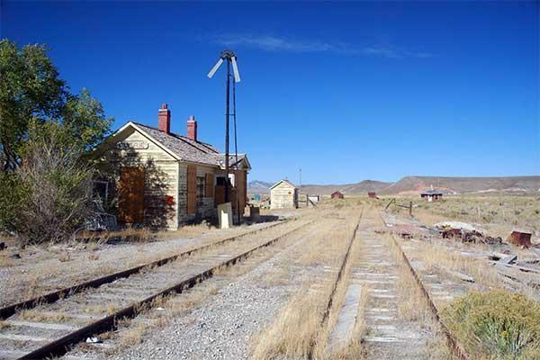
Currie is a very small town located in Elko County, Nevada. Its population is around 20, and is often considered a ghost town. The town is named after Joseph Currie, who started a ranch there in 1885. Discovery of copper in the neighboring town of Ely prompted the building of a railroad from Ely to the Southern Pacific main-line, at Cobre, Nevada. Currie is the mid-point between the two towns. On March 22, 1906, the first passenger train from Cobre to Currie was operated. Between 1906 and 1941, approximately 4.6 million people passed through Currie on rail.
The Ely copper smelters were closed on June 20, 1983 and the railroad closed one day later.
The major portion of the town, the business district (20 acres), is owned by Glenn and Brenda Taylor, who now reside in Utah. It consists of Goshute Mercantile, the bar, adjoining house, cabins, RV park, garage, historic buildings, and corrals. There is also the Northern Nevada Railroad, Elko County School District - Currie Elementary school, Lear Ranch and the Nevada Highway Department. The Tayor's wish to sell their part of the town.
www.elkorose.com/currie.html
Wikipedia article: http://en.wikipedia.org/wiki/Currie,_Nevada
Nearby cities:
Coordinates: 40°16'1"N 114°44'48"W
- McGill, Nevada 95 km
- Barclay, Nevada 307 km
- Wolf Hole, Arizona 401 km
- Bodie State Historic Park 433 km
- Tammukan, California 642 km
- Alum Rock Park 691 km
- Kaiser Mine and Ghost Town 713 km
- China Camp State Park 715 km
- Bombay Beach, California 773 km
- Palisades del Rey (Surfridge Ghost Town) 776 km
- (North) Goshute Mountains 46 km
- Ruby Mountains 61 km
- Pequop Mountain Range 64 km
- Independence Valley 67 km
- East Humboldt Range 76 km
- Toano Range 79 km
- Deep Creek Mountain Range 82 km
- Pond system to Extract Potash & Magnesium Coloride from Salt Brine 84 km
- Bonneville Salt Flats 98 km
- Dugway Proving Ground 116 km