Mahuli Mountains
India /
Maharashtra /
Vashind /
World
/ India
/ Maharashtra
/ Vashind
World / India / Maharashtra / Thane
nature reserve, mountain range
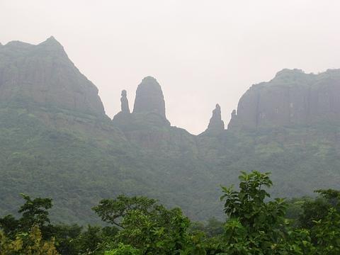


Mahuli is a hill part of the Igatpuri hill range. It has the fort believed to have been used by Shahaji. It is a favourite trekking destination for people from Mumbai and around. Closest railhead is Asangaon. The Forest in and around the Mahuli Mountains has been declared as Protected forest.
Nearby cities:
Coordinates: 19°28'32"N 73°14'24"E
- Konar Zard Kuh 2106 km
- Mazartag 2243 km
- Mulguzar Mountains 2355 km
- Atbashi Range 2429 km
- Kuh-e-Sefid 2751 km
- Kabir Kuh - 3050 m 3074 km
- Sabalan Mountain Range 3303 km
- Sahand Mountain Range 3339 km
- Zangezur Mountains 3476 km
- Gegham mountains 3575 km
- Pinnacle View point 0.7 km
- Mahuli Baan 0.7 km
- Bhatji Pinnacle 0.8 km
- Bahula (Navra) Pinnacle 0.8 km
- Bahuli ( Navri ) Pinnacle 0.9 km
- Mahuli chanderi 1.3 km
- Brahma Vishnu Mahesh Pinnacle 1.4 km
- NANDKESHWAR MANDIR (SHIV-SHANKAR,MARUTI,DATTAGURU,KRISHNA,VITTHAL-RUKHAMAI) 1.6 km
- utani pull 3.8 km
- Govt. Ashram School Dahagaon 4.3 km
Comments