Historic Carnton Plantation (Franklin, Tennessee)
USA /
Tennessee /
Franklin /
Franklin, Tennessee /
Eastern Flank Circle, 1345
World
/ USA
/ Tennessee
/ Franklin
World / United States / Tennessee
museum, plantation, confederate, Federal style (architecture), 1820s construction, Greek Revival (architecture), American Civil War 1861-1865

1345 Eastern Flank Circle
Franklin, TN 37064
(615) 794-0903
www.boft.org/carnton.htm
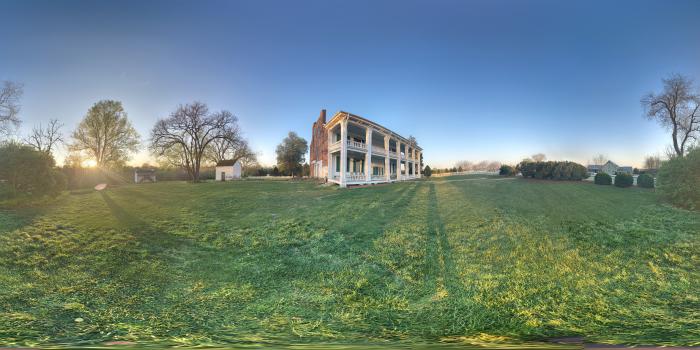
Historic Carnton Plantation is a private non-profit historic site located in Franklin, Tennessee. Late on the afternoon of November 30, 1864, Carnton was witness to one of the bloodiest battles of the entire Civil War, the Battle of Franklin. Carnton, the home of John and Carrie McGavock, served as the main Confederate field hospital for hundreds of wounded and dying soldiers. In 1866, the McGavocks designated two acres of their land as a final burial place for nearly 1,500 Confederate soldiers killed in the Battle of Franklin. Today the site has 48 of the original 1,400 acres and includes the restored antebellum home, a recreated one-acre 1847 garden, slave quarters, smokehouse, springhouse and the adjacent Confederate and family cemetery.
Franklin, TN 37064
(615) 794-0903
www.boft.org/carnton.htm
Historic Carnton Plantation is a private non-profit historic site located in Franklin, Tennessee. Late on the afternoon of November 30, 1864, Carnton was witness to one of the bloodiest battles of the entire Civil War, the Battle of Franklin. Carnton, the home of John and Carrie McGavock, served as the main Confederate field hospital for hundreds of wounded and dying soldiers. In 1866, the McGavocks designated two acres of their land as a final burial place for nearly 1,500 Confederate soldiers killed in the Battle of Franklin. Today the site has 48 of the original 1,400 acres and includes the restored antebellum home, a recreated one-acre 1847 garden, slave quarters, smokehouse, springhouse and the adjacent Confederate and family cemetery.
Wikipedia article: http://en.wikipedia.org/wiki/Carnton
Nearby cities:
Coordinates: 35°54'9"N 86°51'34"W
- Eastern Flank Battle Park 1 km
- Ellington Agricultural Center 21 km
- Andrew Jackson’s Hermitage 42 km
- U.S. Space & Rocket Center 134 km
- Oakville Indian Mounds Park and Museum 164 km
- Cypress Cove Farm 197 km
- Brushy Mountain Correctional Complex 218 km
- Heart of Dixie Railroad 310 km
- Confederate Memorial Park 355 km
- Fort Mitchell Historic Site 429 km
- Sullivan Farms Neighborhood 1.6 km
- Oakwood Estates 2.7 km
- Vanderbilt Legends Golf Course 5.5 km
- OG Fieldstone 7.7 km
- Tollgate Village 8.4 km
- Canterbury 10 km
- Hidden Valley Estates 11 km
- Bridgemore Village 11 km
- Temple Hills Country Club 15 km
- Bowie Nature Park 27 km
Comments