Horirampur Upazila HQ
Bangladesh /
Manikganj /
World
/ Bangladesh
/ Manikganj
/ Manikganj
World / Bangladesh / Dhaka / Dhaka / Manikgonj
township, subdistrict, fourth-level administrative division, local government

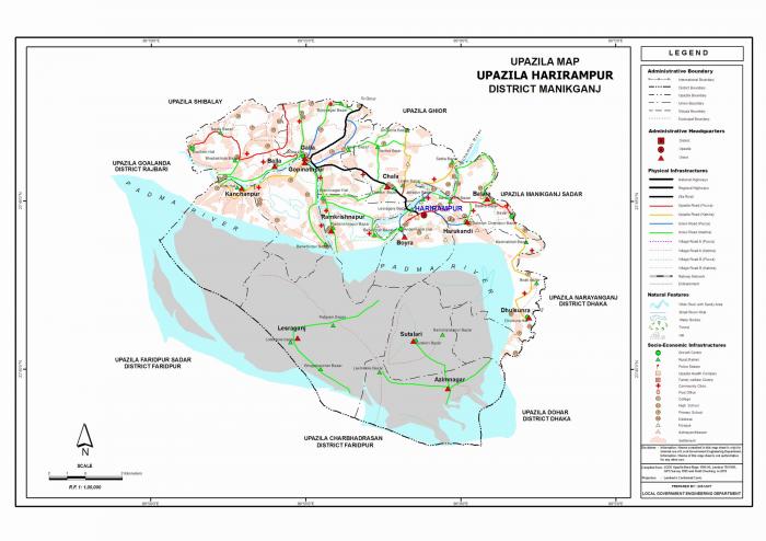
Harirampur Upazila (Manikganj district) with an area of 245.42 sq km, is bounded by Shivalaya, Ghior and Manikganj sadar upazilas on the north, Char Bhadrasan and Faridpur sadar on the south, Manikganj Sadar, Nawabganj (Dhaka) and Dohar upazilas on the east, Shivalaya, Goalandaghat and Faridpur Sadar upazilas on the west. Main rivers are the padma and ichamati; main depressions: Bhatsala and Gharilpur beels. The upazila often becomes victim to river erosion.
Harirampur is located at 23.7333°N 89.9667°E. It has 30136 units of house hold. Harirampur thana was turned into an upazila in 1983. It consists of 13 unions, 196 mouzas and 253 villages.
Heritage: Jhitka Lokmania Dargah.
As of 1991 Bangladesh census, Population 156326; male 49.6%, female 50.4%; Muslim 84.8%, Hindu 14.9%, Christian 0.03%, others 0.27%.
Religious institutions: Mosque 161, mazar 3, dargah 3, temple 73, sacred place 2.
Average literacy 30%: male 36%, female 24%. Educational institutions: college 3, high school (government) 1, high school (non-government) 12, madrasa 7, primary school (government) 68, primary school (non-government) 11, NGO operated school 52, most noted of which is Patgram Anath Bandhu Government High School (1915).
Main occupations Agriculture 35.12%, agricultural labourer 20.76%, fishing 2.77%, industry 1.33%, commerce 11.66%, service 12.31%, wage labourer 3.39% and others 12.66%.
Land use Cultivable land 11759 hectares, fallow land 12786 hectares; single crop 37%, double crop 49%, triple crop 14%. Cultivable land under irrigation 30%.
Land control: Among the peasants, 25% are landless, 20% small peasant, 40% intermediate, 15% rich; cultivable land per head 0.075 hectare.
Communication facilities Roads: pucca 27 km, semi pucca 8 km and mud road 177 km; waterways 26 nautical mile.
Fisheries, poultries and dairies Fishery 52, dairy 20, poultry 60.
Manufactories Flour mill 2, ice mill 2, saw mill 12.
Cottage industries Welding 10, bidi factory 1, handloom 161, bamboo work 198, goldsmith 60, blacksmith 73, potteries 138, tailoring 200.
Health centres Upazila health complex 1, union health centre 5, family planning centre 4, NGO operated health centre 1
NGO activities: Operationally important NGOs are brac, asa, proshika, grameen bank, ccdb, Samamana.
Harirampur (Town) consists of one mouza. It has an area of 11.1 sq km. The total population of the town is 10815; male 49.42%, female 50.52%; literacy rates among the town people 32.6%.
Nearby cities:
Coordinates: 23°44'51"N 89°58'34"E
- Abhaynagar Upazila HQ 98 km
- Fakirhat Upazila HQ 109 km
- Kachua Upazila HQ 120 km
- Sarishabari Upazila 123 km
- Koyra Upzila HQ 169 km
- Shaghatta Upazila 174 km
- Gobindaganj Upazila 183 km
- Bholahat Upazila HQ 226 km
- Maidi Vdc 700 km
- Samote Union Council 1937 km
- Bohulatoli 2.4 km
- Pipuliar chak 2.9 km
- Danistapur 3.5 km
- zitka bazar. monir12001 7 km
- - 7.2 km
- munnu textile gilondo Manikgonj...........monir12001 11 km
- Dhaleshwari River 12 km
- DHAKIJORA 14 km
- Proposed 2nd Padma Bridge, Bangladesh 19 km
- Dhaka Division 58 km