Slavskoye
Russia /
Kaliningrad /
Yuzhnyy /
World
/ Russia
/ Kaliningrad
/ Yuzhnyy
, 18 km from center (Южный)
World / Russia / Kaliningrad
village
Add category


Slavskoye was the prewar German settlement Kreuzburg (in Ostpreussen), before the war also known as Creuzburg, and known in Russian as Krojcburg / Кройцбург. After the war it was renamed Slavskoe (Slavskoye / Славское).
In 1240 German knights conquered the area and founded a castle at the site of an older Prussian one. In 1315 the settlement was granted city rights by the marshall of the German Order Heinrich von Plötzke. Kreuzburg had city walls, a church and a market place. The city found itself in February 1945 in the heat of the battle, in the so-called Heiligenbeiler Kessel, and was nearly completely destroyed during the fighting. After the the settlement was rebuild as Slavskoye, but it lost its city rights.
In 1240 German knights conquered the area and founded a castle at the site of an older Prussian one. In 1315 the settlement was granted city rights by the marshall of the German Order Heinrich von Plötzke. Kreuzburg had city walls, a church and a market place. The city found itself in February 1945 in the heat of the battle, in the so-called Heiligenbeiler Kessel, and was nearly completely destroyed during the fighting. After the the settlement was rebuild as Slavskoye, but it lost its city rights.
Nearby cities:
Coordinates: 54°29'39"N 20°26'35"E
- Poberezhye 2.2 km
- Krasnoarmeyskoye 2.5 km
- Podgornoye 3.9 km
- Vladimirovo 9 km
- Gvardeyskoye 12 km
- Chekhovo (former German village Uderwangen) 18 km
- Piersele 20 km
- Tishino 20 km
- Bezledy (niem. Beisleiden) 25 km
- Shevchenko 36 km
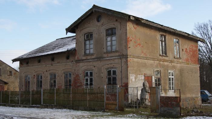
- Castle Krojtsburg. 0.2 km
- Zarechye 2.8 km
- Bagrationovsky urban district 4 km
- Vogelsang 5.7 km
- Former German estate Vorwerk Grünhof 7.1 km
- Former German estate Vorwerk Augustenhof 7.4 km
- Former German estate Vorwerk Louisenhof 8.6 km
- Former German estate Gut Ernsthof 9 km
- Niveskoye military air base 13 km
- Guryevsky municipal district 31 km