Running Creek Falls
Australia /
Queensland /
Nerang /
World
/ Australia
/ Queensland
/ Nerang


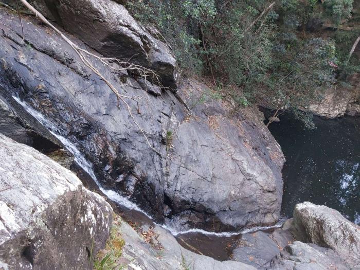
Waterfall on Running Creek, Mount Tamborine, with overall height 15-25 m. Mainly water runs down the steep rocky slope at 60-70 degrees. There is a rockpool at the bottom of the falls. No formed tracks lead to the falls. To reach the falls, follow down the creek from the nearest creek crossing which is 400 m upstream from the falls. Overwise you can use a trail to the south from the creek, and go through the bush 200 m down the slope.
Nearby cities:
Coordinates: 27°55'2"S 153°13'50"E
- ' Our Lady Help Of Christians Shrine Marian Valley Canungra 19 km
- Mount Warren PArk 22 km
- glynton road, 184-194 28 km
- Dunne Farm 29 km
- Ships Stern 30 km
- Kooralbyn Golf Course 43 km
- b4 46 km
- South Ripley QLD 4306 52 km
- Mount Ballow Region 71 km
- Z 71 km
- Jenyns Falls 2.1 km
- Bashkir Falls 2.1 km
- Tamborine Mountain Libray 4.6 km
- Upper Coomera Cemetery 5.1 km
- Thunderbird Park 5.1 km
- Cedar Creek Falls 5.2 km
- Maudsland 5.7 km
- City of Gold Coast, QLD 14 km
- Canungra Military Area 14 km
- Greater Brisbane, QLD 69 km