Pakyong Airport (Pakyong)
India /
Sikkim /
Rangpo /
Pakyong /
Pakyong Airport Road
World
/ India
/ Sikkim
/ Rangpo
airport, 2018 construction
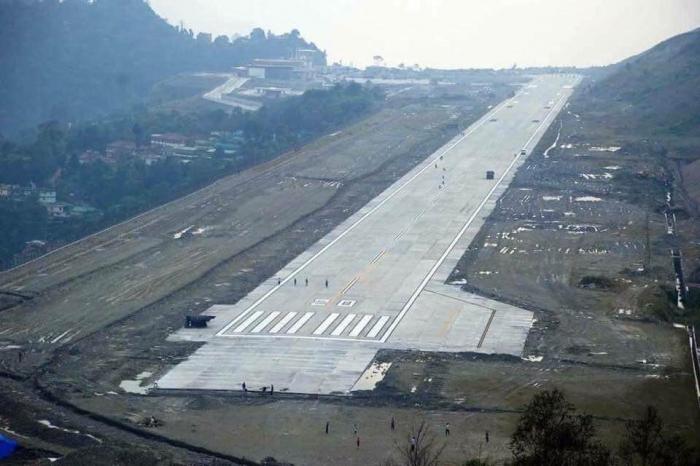
One of the highest airports in India at 4590 feet above sea level.
Serves the state of Sikkim.
35 km from the capital Gangtok.
Serves the state of Sikkim.
35 km from the capital Gangtok.
Wikipedia article: http://en.wikipedia.org/wiki/Pakyong_Airport
Nearby cities:
Coordinates: 27°13'58"N 88°35'18"E
- Pakyong 1.9 km
- Hasimara Air Force Station 95 km
- Andal Airport (AAI) 423 km
- Netaji Subhas Chandra Bose International Airport 507 km
- Gorakhpur Airport / Airforce Station (AFS) 514 km
- Kalaikunda Air Force Station 561 km
- Chakulia Airfield Area WW2 564 km
- Lal Bahadur Shashtri International Airport, Babatpur, Varanasi (U.P.) 606 km
- Trishul Air base - Bareilly Airport / Airforce Station 911 km
- Saifai Airstrip 946 km
- NRC for Orchids (ICAR), Pakyong 0.2 km
- Paddy Fields of Radong 4 km
- agricultural field, saramsa 4.7 km
- College of Agrilcultural Engineering and Post Harvest Technology, (CAEPHT) 6.3 km
- Thapa Dara - Martam 6.6 km
- Gotamey Khet, Martam 6.6 km
- Tibetan village of Shongzhi ཤོག་བཞི།,Sikkim,India 7.2 km
- Jawaharlal Nehru Botanical Garden 7.4 km
- masha 8.7 km
- Sikkim 42 km