Olmos Dam
USA /
Texas /
Alamo Heights /
World
/ USA
/ Texas
/ Alamo Heights
World / United States / Texas
dam
Add category
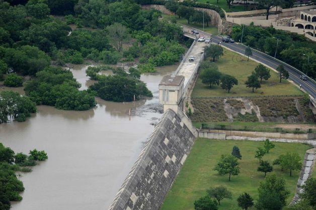
The Olmos Reservoir is on Olmos Creek in the San Antonio River basin four miles north of downtown San Antonio in central Bexar County (at 29°28' N, 98°28' W). The project is owned and operated by the city of San Antonio for flood protection of the downtown area. The reservoir was constructed after the record flood of September 1921, which extensively damaged the San Antonio business district. Construction on the dam was started in 1925 and completed in 1926. The reservoir has a capacity of 15,500 acre-feet and a surface area of 1,050 acres at the top of the dam, which is 728 feet above mean sea level. The reservoir basin is normally empty, and the area is used for parks, playgrounds, and a golf course, except when needed for floodwater storage. The drainage area above the dam is thirty-two square miles. The surrounding terrain is flat to gently rolling and is surfaced by clay loam soils that support mesquite, cacti, and grasses.
www.tsha.utexas.edu/handbook/online/articles/OO/ruo1.ht...
www.tsha.utexas.edu/handbook/online/articles/OO/ruo1.ht...
Nearby cities:
Coordinates: 29°28'21"N 98°28'30"W
- Morganza Spillway 665 km
- Morganza Spillway Structure 674 km
- El Tintero Dam 864 km
- Plutarco Elías Calles Dam 905 km
- Cochiti Dam 1006 km
- Lake Baccarac 1009 km
- Lake Miguel Hidalgo 1042 km
- Angostura Lake 1058 km
- Cherry Creek State Park 1276 km
- McMicken Dam 1403 km
- Brackenridge Park 1.9 km
- Monte Vista 2.2 km
- Alta Vista 3.3 km
- Fort Sam Houston 3.5 km
- Beacon Hill 3.7 km
- Bexar County, Texas 4.1 km
- Northwest Los Angeles Heights 4.1 km
- Los Angeles Heights-Keystone 4.8 km
- Jefferson 5.6 km
- San Antonio International Airport (SAT/KSAT) 6.9 km