Attu Island, Alaska
Russia /
Kamcatka /
Nikolskoye /
World
/ Russia
/ Kamcatka
/ Nikolskoye
, 809 km from center (Никольское)
World
island, battlefield, NRHP - National Register of Historic Places, historic landmark, U.S. National Historic Landmark


Attu is the westernmost and largest island in the Near Islands group of the Aleutian Islands of Alaska, making it the westernmost point of land relative to Alaska and the United States.
Based on Longitude/Latitude, Attu is in reality one of the furthest-east points of the United States, making Semisopochnoi Island to the east the easternmost point of the United States.
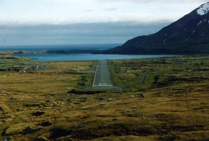
Attu Station was the only post-war inhabited settlement on the island until recent times, with a population of 21 as of the 2010 census. Until the LORAN-C station was decommissioned in 2010 the only year-round occupants were members of the U.S. Coast Guard.
On June 7, 1942 Japanese forces attacked the island. 45 Attuans were taken as prisoners as well as Etta Jones, who was the nurse, schoolteacher, and wife of radio technician Charles Foster Jones. Her husband was tortured, murdered, and beheaded by Japanese soldiers when he refused to repair the radio he just destroyed so it could not be used by the Japanese when they invaded. The native survivors were taken to a prison camp near Otaru, Hokkaidō where over half died from disease and malnutrition. Mrs. Jones was held at a POW camp in Yokohama with Navy weathermen captured at Kiska and was released when the war ended.
The Japanese occupied Attu until May of 1943, when it was recaptured by American forces, ending the only time a foreign force has occupied an American territory.
The Island housed a LORAN radio navigation station operated by the US Coast Guard until it was decommissioned in 2010.
--
Overview:
* www.commerce.state.ak.us/dca/commdb/CIS.cfm?Comm_Boro_n...
Information and period photos:
* en.wikipedia.org/wiki/Battle_of_Attu
* www.alsap.org/Attu/Attu.htm
* www.coretek.org/gsmith/attu.html
* commons.wikimedia.org/wiki/Battle_of_Attu
* www.hlswilliwaw.com/aleutians/attu-homepage.htm
* www.dtic.mil/get-tr-doc/pdf?AD=ADA196078&Location=U...
* Archived Red White Black & Blue (2006) documentary site: bit.ly/3fKse0h
Soldier accounts of the battle: bit.ly/39LOwLq
Based on Longitude/Latitude, Attu is in reality one of the furthest-east points of the United States, making Semisopochnoi Island to the east the easternmost point of the United States.
Attu Station was the only post-war inhabited settlement on the island until recent times, with a population of 21 as of the 2010 census. Until the LORAN-C station was decommissioned in 2010 the only year-round occupants were members of the U.S. Coast Guard.
On June 7, 1942 Japanese forces attacked the island. 45 Attuans were taken as prisoners as well as Etta Jones, who was the nurse, schoolteacher, and wife of radio technician Charles Foster Jones. Her husband was tortured, murdered, and beheaded by Japanese soldiers when he refused to repair the radio he just destroyed so it could not be used by the Japanese when they invaded. The native survivors were taken to a prison camp near Otaru, Hokkaidō where over half died from disease and malnutrition. Mrs. Jones was held at a POW camp in Yokohama with Navy weathermen captured at Kiska and was released when the war ended.
The Japanese occupied Attu until May of 1943, when it was recaptured by American forces, ending the only time a foreign force has occupied an American territory.
The Island housed a LORAN radio navigation station operated by the US Coast Guard until it was decommissioned in 2010.
--
Overview:
* www.commerce.state.ak.us/dca/commdb/CIS.cfm?Comm_Boro_n...
Information and period photos:
* en.wikipedia.org/wiki/Battle_of_Attu
* www.alsap.org/Attu/Attu.htm
* www.coretek.org/gsmith/attu.html
* commons.wikimedia.org/wiki/Battle_of_Attu
* www.hlswilliwaw.com/aleutians/attu-homepage.htm
* www.dtic.mil/get-tr-doc/pdf?AD=ADA196078&Location=U...
* Archived Red White Black & Blue (2006) documentary site: bit.ly/3fKse0h
Soldier accounts of the battle: bit.ly/39LOwLq
Wikipedia article: http://en.wikipedia.org/wiki/Attu_Island
Nearby cities:
Coordinates: 52°52'40"N 172°56'15"E
- Agattu Island, Alaska 49 km
- Buldir Island 206 km
- Kiska Island 300 km
- Segula Island 361 km
- Rat Island 376 km
- Little Sitkin Island 386 km
- Amchitka Island 410 km
- Medny (Copper) Island 423 km
- Semisopochnoi Island 453 km
- Bering Island 542 km
- Holtz Bay, West Arm 15 km
- Holtz Bay, East Arm 16 km
- Hogback Ridge 17 km
- Former Attu Station / Casco Cove Coast Guard Station 17 km
- Holtz Bay 17 km
- Lake Nicholas 20 km
- Massacre Bay 21 km
- Sarana Bay 24 km
- Cape Wrangell 31 km
- Eareckson Air Station (SYA/PASY) 81 km
Comments