Aringay
Philippines /
Ilocos /
San Jose /
World
/ Philippines
/ Ilocos
/ San Jose
World / Philippines / La Union / Aringay
town, municipality, third-level administrative division
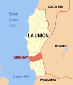
Municipality of Aringay, Province of La Union
Land Area: 84.54 km²
ZIP Code: 2503
Aringay is a coastal municipality in the province of La Union in the Philippines. As of the 2010 Census, it had a population of 44,949 people.
Its boundaries are formed by the municipalities of Caba and Burgos to the north, Agoo to the south, the foothills of the Cordillera Central mountain range to the east, and the South China Sea to the west.
The town experiences the prevailing monsoon climate of Northern Luzon, characterized by a dry season from November to April and a wet season from May to October. Its economy is based primarily on agriculture, producing rice, tobacco and fruit crops as economic staples. A nascent tourism industry is centered on its beach resorts. Its ethnic population is predominantly Ilocano and Christian (Roman Catholic).
Aringay belongs to District 2 in La Union province.
Aringay is politically subdivided into 24 barangays:
-Alaska
-Basca
-Dulao
-Gallano
-Macabato
-Manga
-Pangao-aoan East
-Pangao-aoan West
-Poblacion
-Samara
-San Antonio
-San Benito Norte
-San Benito Sur
-San Eugenio
-San Juan East
-San Juan West
-San Simon East
-San Simon West
-Santa Cecilia
-Santa Lucia
-Santa Rita East
-Santa Rita West
-Santo Rosario East
-Santo Rosario West
History:
Aringay was an ancient village known in pre-colonial times as Alingay or Alinguey. When Spanish colonizers arrived in the late 16th century, they found an enclave of ethnic Pangasinenses actively trading with their Ilocano and Ifugao neighbors and traders from China, Japan and Southeast Asia. The presence of Spanish soldiers, administrators and Augustinian missionaries ushered in the town’s colonial era and its conversion to Roman Catholicism.
Aringay remained a part of Pangasinan province until April 18, 1854, when a royal decree fused the northern towns of that province with the southern towns of Ilocos Sur to create the new province of La Union. The municipalities of Caba and Gallano (later placed in the province of Benguet and then abolished in 1900) were later carved out of Aringay’s northern borders.
The 18th and 19th century marked the active expansion of Ilocano territory. Scores of migrants from the Ilocos provinces pushed their way south so that by the end of the 19th century, Aringay was home to mostly Ilocano and Ilocanized Pangasinan families.
Outbreaks of rebellion rocked the town during four centuries of Spanish, American and Japanese colonization. Bloody confrontations ignited by revolutionaries such as Diego Silang and Gabriela Silang during Spanish occupation and by insurgents during the Philippine-American War and the Japanese occupation in World War II marred the bucolic villages of Aringay.
A decisive battle on Aringay River against U.S. forces crippled Ilocano guerrillas. By 1901 the province of La Union was under American occupation.
Japanese forces attacked Aringay on December 1941 and occupied the town until their brutal withdrawal in 1945-1946, when many Aringayenos were massacred.
Notable people:
* Diego Silang
* Gloria Diaz
Wikipedia article: http://en.wikipedia.org/wiki/Aringay,_La_Union
Nearby cities:
Coordinates: 16°24'40"N 120°24'3"E
- Bokod 36 km
- Kayapa 45 km
- Mangatarem 66 km
- Mabini 66 km
- Santa Cruz 82 km
- Candelaria 94 km
- San Jose 100 km
- Capas 111 km
- Botolan 126 km
- Subic 159 km
- Sitio Corrooy 2.7 km
- Sitio Riverside 2.8 km
- Mushroom Farm alyas "O-Ong"!!!Naimas kabsat!!! 4.4 km
- hillzone 5.2 km
- Aringay Town Proper 5.3 km
- Hacienda Acosta 6.9 km
- Francia Sur 7.4 km
- PIO BALANGUE ESTATE 7.5 km
- La Union 17 km
- Lingayen Gulf 25 km
Comments