Sofi Chay Protected Area
Iran /
Azarbayejan-e Sharqi /
Maragheh /
World
/ Iran
/ Azarbayejan-e Sharqi
/ Maragheh
, 25 km from center (مراغه)
nature conservation park / area
Add category


www.irandeserts.com/content/article/%D9%85%D9%86%D8%B7%...
,
www.iew.ir/1391/06/11/1325 اطلاعات کامل
photo :
www.avalansanandaj.blogfa.com/post/11
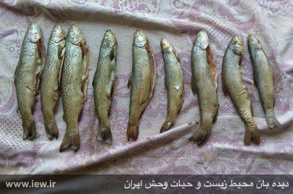
Watch the environment and wildlife Iran: Sofi Chay area due to ecological significance of the existence of the red speckled trout species, the Supreme Council for the Environment Act No. 356 (Commission state infrastructural) dated 2001/10/27 from the hunting ban the protected area has improved.
Sofi Chay Protected Area covers an area of 13097 hectares in the heights above the city of Maragheh Sahand and with an interval of 19. 5 km away that is connected to the area was Sahand.
Sofi Chay river with a length of 20 km within the catchment Sufi Chay in the range of 3 sub-basin Trafayy, high tea and sofi chaydown there and considered one of the sub-basin of Lake Urmia. This river is a river in terms of Astrahlr placed in Category 4, the minimum height of 1900 meters and a maximum altitude of 3400 meters in the mouth and has an average slope of 7. 5 percent.
Comments to being connected to sahand mountain Sufi Chay basin and the existence of permanent springs in the waterway with a relatively high discharge heights from a very high capacity to spawn and winter Red-spotted trout (Brown trout) enjoys hanging out is so that the peak discharge basin of 104 m3/s, and the existence of the alavids dam downstream to its biological feature that adds the correct management and proper protection
,
www.iew.ir/1391/06/11/1325 اطلاعات کامل
photo :
www.avalansanandaj.blogfa.com/post/11
Watch the environment and wildlife Iran: Sofi Chay area due to ecological significance of the existence of the red speckled trout species, the Supreme Council for the Environment Act No. 356 (Commission state infrastructural) dated 2001/10/27 from the hunting ban the protected area has improved.
Sofi Chay Protected Area covers an area of 13097 hectares in the heights above the city of Maragheh Sahand and with an interval of 19. 5 km away that is connected to the area was Sahand.
Sofi Chay river with a length of 20 km within the catchment Sufi Chay in the range of 3 sub-basin Trafayy, high tea and sofi chaydown there and considered one of the sub-basin of Lake Urmia. This river is a river in terms of Astrahlr placed in Category 4, the minimum height of 1900 meters and a maximum altitude of 3400 meters in the mouth and has an average slope of 7. 5 percent.
Comments to being connected to sahand mountain Sufi Chay basin and the existence of permanent springs in the waterway with a relatively high discharge heights from a very high capacity to spawn and winter Red-spotted trout (Brown trout) enjoys hanging out is so that the peak discharge basin of 104 m3/s, and the existence of the alavids dam downstream to its biological feature that adds the correct management and proper protection
Nearby cities:
Coordinates: 37°38'0"N 46°23'15"E
- Lake Urmia 133 km
- Central Alborz Protected Area 427 km
- Kabir Kuh - 3050 m 461 km
- Kavir Protected Area 525 km
- Kavir National Park 584 km
- Touran Wildlife Refuge 875 km
- Naybandan Wildlife Refuge 955 km
- Bahram-e Gur Protected Area 1142 km
- Hamoun Wildlife Refuge 1501 km
- Bahookalat Protected Area 1884 km
- Sahand Mountain Range 6.9 km
- Valley of the Sofi Chay (Maragheh) River 7.9 km
- peak mount sufi - 3340 M 8 km
- Sofi Chay Mount 9 km
- روستاي آلمالو 15 km
- The Hoodoos of Alaviyan-e Maragheh ... Tent Rocks National Monument 24 km
- Alavian Dam Reservoir 24 km
- Mining giant sand washing = Maragheh 3 27 km
- Valley of the Mordigh River (Dayti) 27 km
- گردنه آلقو قاشقاسي 31 km
Sahand Mountain Range
Valley of the Sofi Chay (Maragheh) River
peak mount sufi - 3340 M
Sofi Chay Mount
روستاي آلمالو
The Hoodoos of Alaviyan-e Maragheh ... Tent Rocks National Monument
Alavian Dam Reservoir
Mining giant sand washing = Maragheh 3
Valley of the Mordigh River (Dayti)
گردنه آلقو قاشقاسي