Fort Manoel
Malta /
Inner Harbour /
Floriana /
World
/ Malta
/ Inner Harbour
/ Floriana
World
fortification, closed / former military


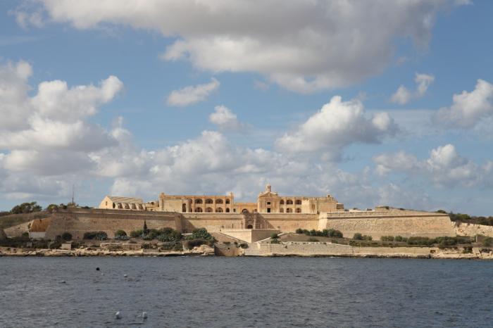


Fort Manoel (Maltese: Forti Manoel or Fortizza Manoel) is a star fort on Manoel Island in Gżira, Malta. It was built in the 18th century by the Order of Saint John, during the reign of Grand Master António Manoel de Vilhena, after whom it is named. Fort Manoel is located to the north west of Valletta, and commands Marsamxett Harbour and the anchorage of Sliema Creek. The fort is an example of Baroque architecture, and it was designed with both functionality and aesthetics in mind.
www.educ.um.edu.mt/militarymalta/html/fort_manoel.html
www.educ.um.edu.mt/militarymalta/html/fort_manoel.html
Wikipedia article: http://en.wikipedia.org/wiki/Fort_Manoel
Nearby cities:
Coordinates: 35°54'10"N 14°30'18"E
- Northern Entrenchment 0.8 km
- Fort St. Angelo 1.5 km
- Enceinte along French Creek 1.7 km
- Fort Ricasoli 1.7 km
- Saint Clement's Retrenchment 3 km
- Mdina 10 km
- Fort Campbell 13 km
- Fort Chambray 24 km
- Underground Bunkers 356 km
- Aircraft shelters 450 km
- Manoel Island 0.3 km
- Marsamxett Harbour 0.3 km
- Grand Harbour 1.6 km
- Senglea (L-Isla) 2 km
- French Creek 2.2 km
- Malta Shipyards Ltd. 2.3 km
- The Three Cities/Cottonera 2.3 km
- Xghajra 4.3 km
- Malta 5.2 km
- Malta Channel 49 km