Von Schmidt Survey Marker
USA /
Nevada /
Searchlight /
World
/ USA
/ Nevada
/ Searchlight
Survey Marker placed by Alexey W Von Schmid.
Background: When California was created in 1849, California decreed its northern border to be the 42nd parallel of north latitude. From there, the eastern border followed the 120th meridian of longitude south to where it intersects the 39th parallel of latitude (this spot turned out to be in the middle of Lake Tahoe). From that point in Lake Tahoe, the border was decreed to be a straight line running southeasterly to the Colorado River, at a point where the Colorado intersects the 35th parallel. Determining the location of the 120th meridian was pretty difficult in the 1800s, and several surveys were made, resulting in boundary lines between California and Nevada that were as much as 3 miles apart.
One of the surveys was done by a fellow named Alexey W Von Schmidt, who was hired in 1872 to survey the boundary. About 20 yrs later, the US Coast and Geodetic Survey did a second survey of the boundary from Lake Tahoe south to the Colorado River, finding that Von Schmidt's line was off a bit, in some places too far east, and in other places too far west. Arguments and lawsuits persisted, until finally in 1980 the US Supreme Ct decided that Von Schmidt's line would be the boundary north of Lake Tahoe, and the USC&G's survey line would be the boundary from Lake Tahoe south to the Colorado River.
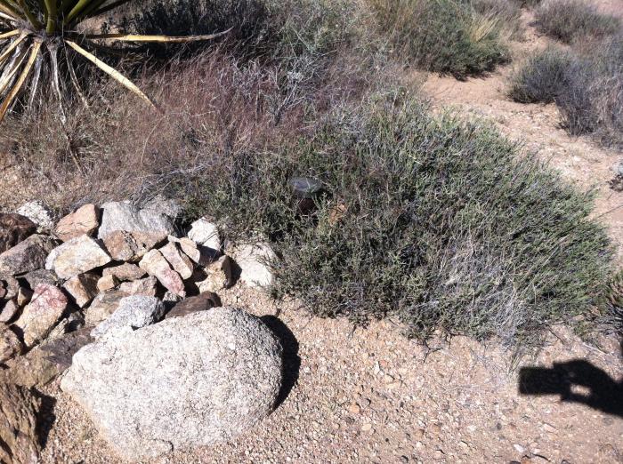
As Von Schmidt was surveying, he placed markers (monuments) in the ground every so often as he went along. I've visited a few, and they all appear to be missing - long gone. Von Schmidt placed one at this location, and - as it's out in the middle of nowhere - I thought maybe this historical survey monument was still there. It's not (least I couldn't find it . . .).
Link to the USGS map showing the location:
mapper.acme.com/?ll=35.42179,-115.16937&z=15&t=T
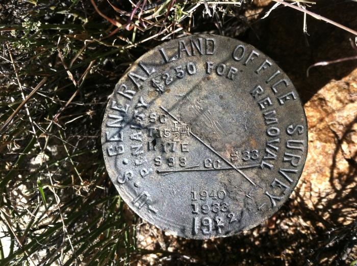
Appears Von Schmidt's marker was replaced in 1922 with a more recent style survey monument (see pic)
Coordinates for the monument are 35.42183°N 115.17101°W
About 300' north, there is a wash that connects with the nearest road approx 6/10 of a mile to the east. I would have thought it would be possible to drive from the road down the wash to close to the monument, but in Oct of 2016, the wash had too much vegetation to allow a vehicle to pass.
About 100' east of the monument there is a faint road. This road appears to have been put in to support a mining claim
Background: When California was created in 1849, California decreed its northern border to be the 42nd parallel of north latitude. From there, the eastern border followed the 120th meridian of longitude south to where it intersects the 39th parallel of latitude (this spot turned out to be in the middle of Lake Tahoe). From that point in Lake Tahoe, the border was decreed to be a straight line running southeasterly to the Colorado River, at a point where the Colorado intersects the 35th parallel. Determining the location of the 120th meridian was pretty difficult in the 1800s, and several surveys were made, resulting in boundary lines between California and Nevada that were as much as 3 miles apart.
One of the surveys was done by a fellow named Alexey W Von Schmidt, who was hired in 1872 to survey the boundary. About 20 yrs later, the US Coast and Geodetic Survey did a second survey of the boundary from Lake Tahoe south to the Colorado River, finding that Von Schmidt's line was off a bit, in some places too far east, and in other places too far west. Arguments and lawsuits persisted, until finally in 1980 the US Supreme Ct decided that Von Schmidt's line would be the boundary north of Lake Tahoe, and the USC&G's survey line would be the boundary from Lake Tahoe south to the Colorado River.
As Von Schmidt was surveying, he placed markers (monuments) in the ground every so often as he went along. I've visited a few, and they all appear to be missing - long gone. Von Schmidt placed one at this location, and - as it's out in the middle of nowhere - I thought maybe this historical survey monument was still there. It's not (least I couldn't find it . . .).
Link to the USGS map showing the location:
mapper.acme.com/?ll=35.42179,-115.16937&z=15&t=T
Appears Von Schmidt's marker was replaced in 1922 with a more recent style survey monument (see pic)
Coordinates for the monument are 35.42183°N 115.17101°W
About 300' north, there is a wash that connects with the nearest road approx 6/10 of a mile to the east. I would have thought it would be possible to drive from the road down the wash to close to the monument, but in Oct of 2016, the wash had too much vegetation to allow a vehicle to pass.
About 100' east of the monument there is a faint road. This road appears to have been put in to support a mining claim
Nearby cities:
Coordinates: 35°25'18"N 115°10'15"W
- True Nevada Border 1.1 km
- Gold Bronze Mine 12 km
- Dead Mountains Wilderness Area 49 km
- Desert Canyon Development 63 km
- Laughlin Ranch 64 km
- Los Lagos Subdivision 73 km
- MESQUITE CREEK 74 km
- Mineral Park 92 km
- Arizona Route 66 Motorsports Park 109 km
- Desert Hills, AZ 121 km
- Castle Mountain Mine 17 km
- Searchlight, Nevada 24 km
- Grotto Hills 29 km
- Cal-Nev-Ari, Nevada 30 km
- Lake Mohave 48 km
- Mojave National Preserve 50 km
- Big Bend State Recreation Area 58 km
- Camp Ibis 59 km
- Laughlin, Nevada 59 km
- Dead Mountains Wilderness Area 62 km