Makhmur District (KRG) (Koze Panke)
Iraq /
Irbil /
Koze Panke
World
/ Iraq
/ Irbil
/ Irbil
, 44 km from center (اربيل)
second-level administrative division, draw only border
The part of he northern Iraqi Makhmur district that is controlled by the Kurdish Regional Government (KRG) in Erbil.
Current Military situation:
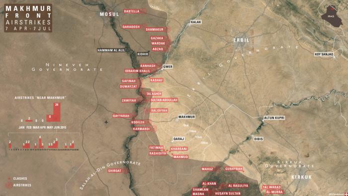
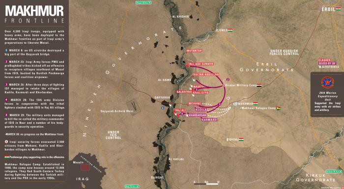
The Peshmerga Forces of the Kurdistan Regional Government hold most part of the district. The current frontline with ISIS lies west of Mount Sultan Abdullah and south of Qaraj and Graw villages. The Iraqi Army control the villages around Hajj Ali villages and across the Tigris river. Near Mexmûr city, there are 2 Military Bases, one used by the Iraqi Army to launch Ofensives against ISIS, and other used by the United States Military, to give Artillery support for Peshmerga and Iraqi Forces in the area.
Source: twitter.com/LCarabinier/status/715276927095930880
History:
Makhmour has been part of Erbil since the founding of the modern Iraqi state. However, Ninewa has administered the district since the Green Line was established in 1991. Despite this, UNAMI could not find legal documentation officially redrawing Erbil and Ninewa’s provincial boundaries to reflect this.
The Ninewa office of the Article 140 Committee received approximately 20,000 claims for compensation from Kurdish families displaced from Makhmour during the 1990s. This is the highest number of claims from any district in Ninewa.
Current Military situation:
The Peshmerga Forces of the Kurdistan Regional Government hold most part of the district. The current frontline with ISIS lies west of Mount Sultan Abdullah and south of Qaraj and Graw villages. The Iraqi Army control the villages around Hajj Ali villages and across the Tigris river. Near Mexmûr city, there are 2 Military Bases, one used by the Iraqi Army to launch Ofensives against ISIS, and other used by the United States Military, to give Artillery support for Peshmerga and Iraqi Forces in the area.
Source: twitter.com/LCarabinier/status/715276927095930880
History:
Makhmour has been part of Erbil since the founding of the modern Iraqi state. However, Ninewa has administered the district since the Green Line was established in 1991. Despite this, UNAMI could not find legal documentation officially redrawing Erbil and Ninewa’s provincial boundaries to reflect this.
The Ninewa office of the Article 140 Committee received approximately 20,000 claims for compensation from Kurdish families displaced from Makhmour during the 1990s. This is the highest number of claims from any district in Ninewa.
Wikipedia article: https://en.wikipedia.org/wiki/Makhmur_District
Nearby cities:
Coordinates: 35°52'24"N 43°41'44"E
This article is protected.
- Salahadin Governorate (ICR) 111 km
- Hewlêr/ Erbil Province 164 km
- South Kurdistan / Iraqi Kurdistan 273 km
- Al-Qa'im District (ICR) 361 km
- Deir ez-Zor Civil Council (DFNS) 363 km
- Deir ez-Zor Governorate (PCS) 402 km
- Cizîre/Jazira Region (DFNS) 408 km
- Anbar Governorate (ICR) 451 km
- Markaz Rutba Subdistrict (ICR) 481 km
- Al-Walid Subdistrict (ICR) 497 km
- نزيك ديبةكةي كوردستاني 5.5 km
- Wali Kazhraw hill 7.4 km
- Mining Area 11 km
- Mount Qarachoq (North) 13 km
- Hecî Şêxan 14 km
- Mexmûr Cemetery 15 km
- Makhmur Refugee Camp 15 km
- Defensive Berm 15 km
- Qarachoq Mountain (South) 21 km
- Qani Domlan Ridge 39 km