Kerr Lock - Wabash-Erie canal (Lagro, Indiana)
USA /
Indiana /
Lagro /
Lagro, Indiana
World
/ USA
/ Indiana
/ Lagro
World / United States / Indiana
interesting place
Add category
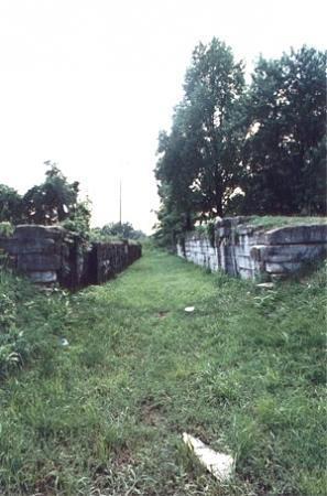
This is part of a lock still visible on the Wabash Erie canal there is also a log cabin to view.
The canal was extended to the Ohio River via such towns as Logansport, Lafayette, and Evansville. To lure Irish and German Immigrants to work on the Canal, the trustees offered land around the Canal for very attractive prices. This brought the necessary labor into the area, but it also brought conflicts. It was said that while building a section of the canal near Largo,Indiana, a great riot broke out between Irish Catholics and Irish Protestants. It was so big that the State Milita had to be brought in to settle it. Any future scuffles would result in jail time. The entire Canal opened officially on July 4th, 1843 to great fanfare. Political speeches declared that a great form of transportation had been created that will last for many years. Little did the speakers know of the irony in what they were telling the public
The Canal saw its heyday during the 1850's. Merchant boats and dignitaries made their way back and forth from Fort Wayne. Downtown Fort Wayne was a bustling business center with mills, hotels,and dry goods warehouses. The population had increased three fold. While Fort Wayne was prospering from the canal, the upkeep of this great system was taking its toll. Most of the auqaducts and culverts east of Logansport were made of wood. The erosion of the wood was costing the state more and more money. In addition to the costly upkeep, the Canal office in Fort Wayne suffered from mismanagement and loss of profit. One method of prolonging the life of the Canal was to build a series of plank roads to make it easier to distribute goods farther away from the Canal ports. Plank roads would be built to cover the dirt paths that existed at that time. Virgin timber was readily available from the nearby forests. The Lima Plank Road was the road to the north. The Piqua Plank road (now Calhoun St.) lead to the southeast, and the Goshen Plank Road led to the northwest. While these new roads helped, they were no match for what was to come.
A new less-costly source of transportation was on the horizon. A steam-powered machine placed on rails could transport goods alot faster than the slower Canal. The end of the Canal was in site. Ironically, the first locomotive to arrive in Fort Wayne was transported via canalboat. By the time of theCivil War, Canal use began to wane. At last, Fort Wayne had outgrown the form of transportation that had fostered its roots. Finally, in 1874 the last canal boat docked in Huntington, and the Great Waterway was abandoned. Samuel Hanna who was so instrumental in getting the Canal project going was just as persuasive in ending it. He would go on to help usher in the railroad age.
Wikipedia article: http://en.wikipedia.org/wiki/Wabash-Erie_Canal
Nearby cities:
Coordinates: 40°50'13"N 85°43'30"W
- Fairmount, Indiana 45 km
- Conner Prairie Interactive History Park 98 km
- Prophetstown State Park 101 km
- Indiana State Fairgrounds & Event Center 117 km
- Indianapolis Motor Speedway (IMS) 123 km
- Hayes Regional Arboretum 133 km
- Wayross Conference Center and Camp 178 km
- Site of Gulf Oil Refinery 201 km
- Charles C. Deam Wilderness Area 204 km
- Cincinnati Subway (Abandoned) 215 km
- Salamonie River State Forest 3.4 km
- Wabash County, Indiana 5.8 km
- Salamonie Lake 12 km
- MONUMENT CITY, INDIANA (GHOST TOWN) 15 km
- Huntington County, Indiana 20 km
- Aggregate Mine 23 km
- Kil-So-Quah State Recreation Area 24 km
- Little Turtle State Recreation Area 24 km
- J. Edward Roush Lake 25 km
- J.E. Roush Fish and Wildlife Area 28 km