Daugo
Papua New Guinea /
National Capital District /
Port Moresby /
World
/ Papua New Guinea
/ National Capital District
/ Port Moresby
World / Papua New Guinea / Central
island
Add category

Daugo (also commonly called Fishermans Island) is a popular picnic and swimming spot on weekends. Accessible by boat. The World War II airfield was still used as an emergency airfield right up to late 1980's.
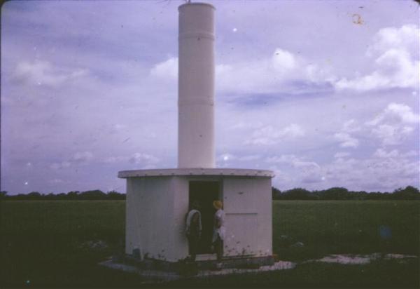
DCA built a VOR (an aircraft navigational aid) there in 1971. It had hundreds of balanced modulators. Photo shows T Shimmin at door entrance.
DCA built a VOR (an aircraft navigational aid) there in 1971. It had hundreds of balanced modulators. Photo shows T Shimmin at door entrance.
Nearby cities:
Coordinates: 9°30'48"S 147°3'35"E
- Goodenough Island 335 km
- Fergusson Island 370 km
- Normanby Island 405 km
- Trobriand Islands 407 km
- Sideia 421 km
- Sanaroa 427 km
- Basilaki 437 km
- Kiriwina 450 km
- Umboi 458 km
- Conflict Islands 523 km
- Fishermans Airfield 1 km
- WWII Gun Emplacements (Basalisk Battery). [Historical] 5.5 km
- Konebada Point 5.8 km
- Idlers Bay 6 km
- Idler's Bay 6.8 km
- Gemo Island Gun Battery. [Historical] 7 km
- Leper Colony in Port Moresby 7.7 km
- Basilisk Passage 8.2 km
- Ski Grounds 8.6 km
- Puma Oil Refinery 8.7 km
Comments