Cheltenham Badlands (Caledon, Ontario)
Canada /
Ontario /
Georgetown /
Caledon, Ontario /
Olde Base Line Rd, 1501-1901
World
/ Canada
/ Ontario
/ Georgetown
World / Canada / Ontario / Peel
nature preserve
Add category


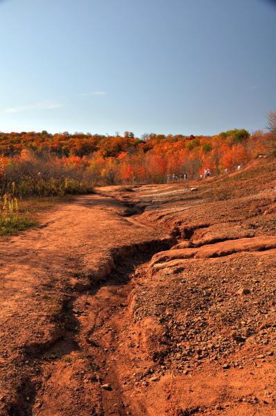
Cheltenham Badlands is a small example of badlands formation in Caledon, Ontario.
The site is located on the south east side of Olde Base Line Road, between Creditview and Chinguacousy Roads, west of Highway 10 in Caledon, and features exposed and eroded Queenston Shale. The formation is located along the Niagara Escarpment.
The site is located on the south east side of Olde Base Line Road, between Creditview and Chinguacousy Roads, west of Highway 10 in Caledon, and features exposed and eroded Queenston Shale. The formation is located along the Niagara Escarpment.
Wikipedia article: http://en.wikipedia.org/wiki/Cheltenham_Badlands
Nearby cities:
Coordinates: 43°46'20"N 79°56'39"W
- Luther Marsh Conservation Area 49 km
- Dundas Valley 58 km
- Conostogo Conservation Area 69 km
- Wainfleet Bog Conservation Area 106 km
- Tionesta Scenic and Natural Research Areas 246 km
- Point Pelee National Park 291 km
- Highland State Recreation Area 322 km
- Shiawassee National Wildlife Refuge 334 km
- Metzger Marsh Wildlife Area, Ottawa National Wildlife Refuge, Magee Marsh Wildlife Area 359 km
- Oak Openings Preserve Metropark 403 km
- Caledon Country Club 2 km
- Southdown Farm 3.6 km
- Poltawa Country Club 5 km
- Brampton Flying Club 5.7 km
- Devils Pulpit Golf Course 7.5 km
- Sligo Hill 9 km
- Valleywood 10 km
- Banty's Roost Golf & Country Club 11 km
- Stonegate 12 km
- Heart Lake Conservation Area 12 km
Comments