Sumbawa
Indonesia /
Nusa Tenggara Barat /
Sumbawa /
World
/ Indonesia
/ Nusa Tenggara Barat
/ Sumbawa
World / Indonesia / Nusa Tenggara Barat
island
Add category


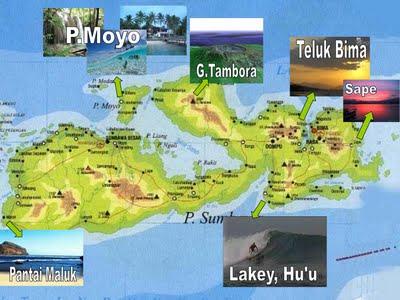
Sumbawa is an Indonesian island, located in the middle of the Lesser Sunda Islands chain, with Lombok to the west, Flores to the east, and Sumba further to the southeast. It is in the province of West Nusa Tenggara.
Sumbawa is 15,448 km2 or 5,965 sq mi (three times the size of Lombok) with a current population of around 1.33 million. It marks the boundary between the islands to the west, which were influenced by religion and culture spreading from India, and the region to the east that was not so influenced. In particular this applies to both Hinduism and Islam.
Sumbawa is 15,448 km2 or 5,965 sq mi (three times the size of Lombok) with a current population of around 1.33 million. It marks the boundary between the islands to the west, which were influenced by religion and culture spreading from India, and the region to the east that was not so influenced. In particular this applies to both Hinduism and Islam.
Wikipedia article: http://en.wikipedia.org/wiki/Sumbawa
Nearby cities:
Coordinates: 8°35'42"S 117°57'23"E
- Pulau Moyo 73 km
- Lombok 239 km
- Nusa Penida Island 276 km
- Sepanjang Island 295 km
- Kangean Island 363 km
- Bali 393 km
- Sapudi Island 441 km
- Nusa Barung 517 km
- Pulau Madura 614 km
- Bawean Island 676 km
- Saleh Bay 13 km
- U/N Reef 14 km
- Doro Ncanga 16 km
- Santong Gulf 16 km
- Toro Oimengi Cape 16 km
- Gili Tenar 19 km
- Research-2 20 km
- (Pulau) Tanjung Dewa 21 km
- Kecamatan Plampang 26 km
- Tambora National Park 37 km