BMEWS AN/FPS-50 Radars (Site)
USA /
Alaska /
Anderson /
World
/ USA
/ Alaska
/ Anderson
military, radar station, closed / former military
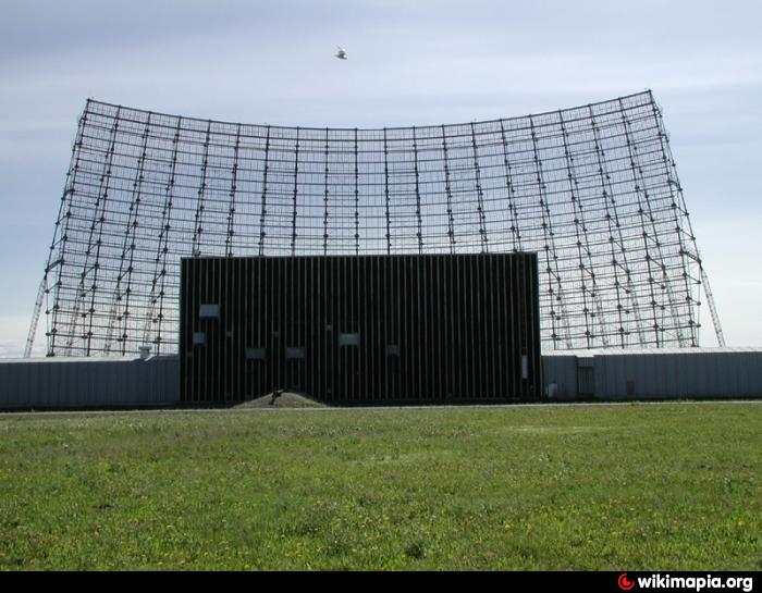
The General Electric AN/FPS-50 Radars located at BMEWS Site 2 were a trio of UHF (440MHz) detectors equipped with fixed 1,500 ton parabolic-torus reflectors and organ-pipe scanner feeds. The units processed data through a Doppler filter bank to scan with 2 horizontally-sweeping fans for as many as ~12,000 observations per day for surveillance of space objects.
The very large fixed rectangular partial-parabolic reflectors allowed the radars to detect targets across a very wide horizontal front at two narrow vertical angles. These were used to provide wide-front coverage of missiles rising into their radar horizon, and by tracking them at two points as they climbed, enough information to determine their rough trajectory. This information would then be fed to a AN/FPS-92 Radar which would fine-tune tracking of selected targets, the end result being high-resolution angular and ranging information on any inbound projectiles.
The system operated from 1961 through the mid-1990s when the adjacent Solid-State Phased-Array Radar System was constructed and eventually assumed the space monitoring role. The parabolic reflectors were subsequently demolished in the mid-2000s.
radomes.org/museum/showsite.php?site=BMEWS+Site+2%2C+Cl...
Wikipedia article: https://en.wikipedia.org/wiki/Ballistic_Missile_Early_Warning_System
Nearby cities:
Coordinates: 64°17'19"N 149°11'28"W
- Clear Air Force Station 5.1 km
- Blair Lake Air Force Range, AK 73 km
- Fort Wainwright 96 km
- Eielson Air Force Base, AK (EIL/PAEI) 109 km
- Donnelly Training Area, AK 144 km
- Fort Greely Missile Defense Command Base 168 km
- Gerstle River Arctic Test Site 196 km
- Fort Richardson 322 km
- Elmendorf Air Force Base (EDF/PAED) 333 km
- Fort Richardson Army Base 333 km
- PACL Clear Airport 3.9 km
- Clear, Alaska 8.2 km
- Nenana Municipal Airport 29 km
- Four Mile Road, Aaska 35 km
- GESKAKMINA LAKE 67 km
- Baker Lake 100 km
- Eureka Creek Gold Mining Area 111 km
- Tofty, AK (site) 120 km
- Fish Lake 135 km
- Native Cemetery 140 km