Mach Loop
United Kingdom /
Wales /
Dolgellau /
World
/ United Kingdom
/ Wales
/ Dolgellau
valley, invisible
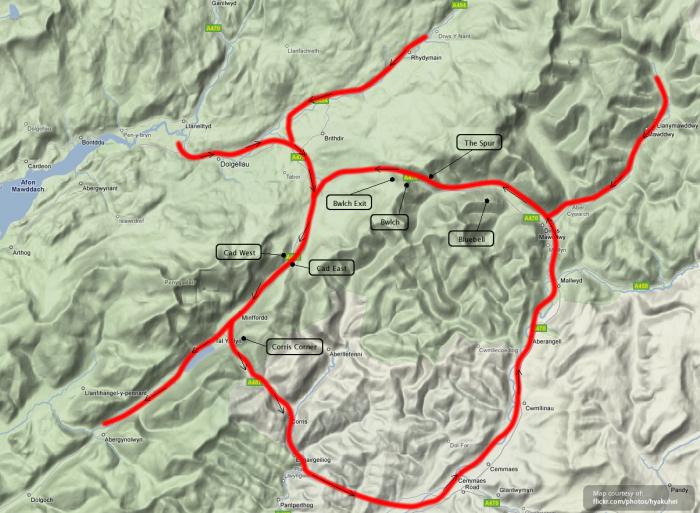
The Mach Loop is a set of valleys, situated between Dolgellau in the north, and Machynlleth in the south (and from which the Mach Loop gets its name), which are regularly used for low level flight training, with flying as low as 250 feet (76 metres) from the nearest terrain.
The system of valleys lies 8 miles east of Barmouth and is nestled between the towns of Dolgellau to the north and Machynlleth to the south, the latter of which it takes its name from. The training area is within the Low Flying Area (LFA) LFA7, which covers most of Wales. Aircraft which use the training area include Royal Air Force Tornado, Typhoon, and Hawk jets, as well as U.S. Air Force F-15E Strike Eagles, which are based at RAF Lakenheath in eastern England.
machloop.co.uk
www.aircanon.co.uk/themachloop
Wikipedia article: http://en.wikipedia.org/wiki/Mach_Loop
Nearby cities:
Coordinates: 52°41'39"N 3°47'16"W
- Glens of Antrim (Glinntí Aontroma) 327 km
- Valle del Corneja 1355 km
- las Batuecas - Sierra de Francia Natural Park 1363 km
- Wad L'Mahsat 2527 km
- Wad Draa 2572 km
- Wad Draa 2740 km
- Wad Draa 2749 km
- Uad Lemluia / Jeneig Ramla 3046 km
- Uad-ad-Dahab 3356 km
- Tenebrourette lost river 3714 km
- Chwarel Llechi'r Aberllefenni 2.8 km
- Camlan 6.2 km
- The Centre for Alternative Technology 8.7 km
- Cemmaes Wind Farm 9 km
- Llyn Coch-hwyad 13 km
- Glaslyn 19 km
- Carno Wind Farm 20 km
- Pumlumon 24 km
- Llyn Clywedog 25 km
- Parc Cenedlaethol Eryri (Snowdonia National Park) 25 km