New River (Mexicali)
Mexico /
Baja California /
Mexicali
World
/ Mexico
/ Baja California
/ Mexicali
Originally a delta arm of the Colorado River, prior to the 1900s, the New River was little more than a shallow depression in the ground, with a few small ponds that would fill with water when the Colorado experienced a significant flood. After the Colorado river broke thru into the Alamo Canal in 1905, the entire flow of the Colorado River flowed into the Alamo Canal for almost 2 yrs. As the Alamo Canal was not lg enough to hold the flow of the entire Colorado River at flood stage, the Colorado overflowed the banks of the canal, and a significant portion of the water flowed southwest toward Volcano Lake, and eventually found its way into the New River. From there, the water followed the New River north into the Salton Sink, forming the Salton Sea.
The record setting flows of the Colorado River in 1905-06 soon eroded the soft soils underlying the New River, tremendously enlarging & deepening the New River, and washing huge amts of soil down into the Salton Sink. Eventually, in Feb of 1907, the Southern Pacific Railroad was able to dam the intake on the Alamo Canal, and return the Colorado River to its orig course south to the Sea of Cortez. Thereafter, the New River became little more than a drainage ditch, into which virtually everything unwanted was dumped.
In the latter half of the 20th century, Mexicali grew tremendously, and the burgeoning city found the New River a very convenient place to dump its civic and industrial waste.
Today, the New River is considered one of the most polluted rivers in the world.
The section of the New River outlined here has been buried in underground culverts by the City of Mexicali, with Bulevar Rio Nuevo constructed on top.
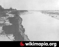
1906 photos of the New River in Mexicali are here:
books.google.com/books?id=6FpDAAAAYAAJ&printsec=frontcover#v=onepage&q&f=false
at pg 36
The record setting flows of the Colorado River in 1905-06 soon eroded the soft soils underlying the New River, tremendously enlarging & deepening the New River, and washing huge amts of soil down into the Salton Sink. Eventually, in Feb of 1907, the Southern Pacific Railroad was able to dam the intake on the Alamo Canal, and return the Colorado River to its orig course south to the Sea of Cortez. Thereafter, the New River became little more than a drainage ditch, into which virtually everything unwanted was dumped.
In the latter half of the 20th century, Mexicali grew tremendously, and the burgeoning city found the New River a very convenient place to dump its civic and industrial waste.
Today, the New River is considered one of the most polluted rivers in the world.
The section of the New River outlined here has been buried in underground culverts by the City of Mexicali, with Bulevar Rio Nuevo constructed on top.
1906 photos of the New River in Mexicali are here:
books.google.com/books?id=6FpDAAAAYAAJ&printsec=frontcover#v=onepage&q&f=false
at pg 36
Wikipedia article: http://en.wikipedia.org/wiki/New_River_(Mexico_–_United_States)
Nearby cities:
Coordinates: 32°38'2"N 115°28'18"W
- Unidad Deportiva UABC. 2.8 km
- CESPM 3.5 km
- Enrique Camarena JR High 4.8 km
- Ibizza NYO 5.6 km
- Rincon Cataviña 5.8 km
- Private Vistermosa 5.8 km
- Santo Domingo 5.9 km
- Villa Colonial 6 km
- Central Main Canal 6.2 km
- Mexico / United States Border 11 km
- Civic Center - Government Offices 0.9 km
- Mall 0.9 km
- Centro Civico 0.9 km
- Sonora-Baja California Railroad Station 1 km
- Bosque de la Ciudad 1.5 km
- Fimbres Plaza 2.1 km
- Soriana Shopping Center 2.1 km
- Municipal Cemetery 2 2.5 km
- Plaza La Cachanilla 2.8 km
- Downtown Mexicali 3.5 km