Roman Aqueduct (Bethlehem)
Palestine /
Bayt Lahhm /
Bethlehem
World
/ Palestine
/ Bayt Lahhm
/ Bayt Lahhm
, 1 km from center (بيت لحم)
place with historical importance, aqueduct, refugee camp, history museum


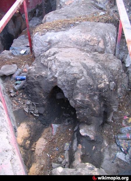

Sections of a Roman aqueduct (2nd-3rd century), consisting of large, fitted sections of stone pipe (a siphon), is visible in this area. It was part of the Upper Aqueduct which carried water from Solomon's Pools, south of Bethlehem, all the way to Jerusalem, beginning in the 1st century BC. The stone pipe visible here is actually a Late Roman (2nd/3rd century AD) reworking of the line; Herod's original channel here was elevated on arches, of which traces were discovered in the 1990s (but are no longer visible).
(1) Opposite the Bethlehem Bible College, across Hebron Rd., the pipe sctions can be seen underlying the houses of the Beit Jibrin (or "Azzeh") Refugee Camp. (People live here -- on top of the pipe! -- so be courteous.) www.unrwa.org/etemplate.php?id=110
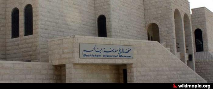
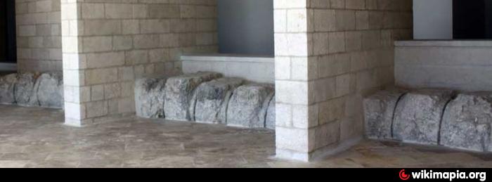
(2) Proceeding northward along the main street, another impressive stretch of stone pipe is protected in-place within the ground floor of the Bethlehem Historical Museum. Here the conduit curves to the east a bit. Even if the museum is closed, the aqueduct is visible through the glass doors facing the street. View a slide-show on the Museum's web-site: www.bethawu.org/museums/bethlehem-historical-museum.
(3) Nearby (around the corner to the north) another bit can be viewed beneath hinged metal doors set in the sidewalk, on the west side of Manger Street opposite the road junction. (Palestinian policemen are on duty at the junction -- ask for permission to lift the doors and see the "Canal Romani".)
(1) Opposite the Bethlehem Bible College, across Hebron Rd., the pipe sctions can be seen underlying the houses of the Beit Jibrin (or "Azzeh") Refugee Camp. (People live here -- on top of the pipe! -- so be courteous.) www.unrwa.org/etemplate.php?id=110
(2) Proceeding northward along the main street, another impressive stretch of stone pipe is protected in-place within the ground floor of the Bethlehem Historical Museum. Here the conduit curves to the east a bit. Even if the museum is closed, the aqueduct is visible through the glass doors facing the street. View a slide-show on the Museum's web-site: www.bethawu.org/museums/bethlehem-historical-museum.
(3) Nearby (around the corner to the north) another bit can be viewed beneath hinged metal doors set in the sidewalk, on the west side of Manger Street opposite the road junction. (Palestinian policemen are on duty at the junction -- ask for permission to lift the doors and see the "Canal Romani".)
Nearby cities:
Coordinates: 31°42'58"N 35°12'6"E
- Al-Eizariya 8.7 km
- City Center 8.9 km
- Mount Scopus 10 km
- E1 Development Area 12 km
- Gush Etzion 26 km
- Jericho 29 km
- Dhiban 57 km
- Wadi Aymah "Al Mashari" 96 km
- Wadi Namtah 103 km
- Wadi Al Labun 110 km
- Gilo 2.2 km
- Har Homa 2.3 km
- Hindaza 3 km
- Sur Baher 3.8 km
- Bethlehem Governorate 5.4 km
- Gush Etzion 5.9 km
- East Jerusalem 6.5 km
- Judea 17 km
- Judaean Desert 24 km
- Judea and Samaria ("West Bank") 26 km