Tungipara Upazila HQ
Bangladesh /
Gopalganj /
Tungi Para /
World
/ Bangladesh
/ Gopalganj
/ Tungi Para
World / Bangladesh / Dhaka / Faridpur / Gopalgonj
township, subdistrict, fourth-level administrative division, local government

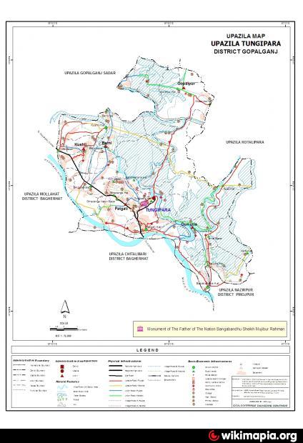
Tungipara Upazila (Gopalganj district) with an area of 127.25 sq km, is bounded by Gopalganj sadar and Kotwalipara upazilas on the north, Chitalmari and Nazirpur upazilas on the south, Kotwalipara upazila on the east, Mollahat and Gopalganj Sadar upazilas on the west. Main rivers: Madhumati, Ghagat and Shailadaha.
The location of Tungipara town is 22.9079372N 89.8997283E. Tungipara (Town) a municipal town, consists of 9 wards and 13 mahallas. The area of the town is 30.39 sq km. The town has a population of 30747; male 51.09%, female 48.91%; density of population is 1012 per sq km. Literacy rate among the town people is 36.1%.
Tungipara thana was turned into an upazila in 1995. It consists of one municipality, 5 union parishads, 34 mouzas, 67 villages.
As of the 1991 Bangladesh census: Population 88102; male 51.25%, female 48.75%; Muslim 65.05%, Hindu 34.74% and others 0.21%.
Religious institutions: Mosque 155, temple 50, church 3.
Literacy and educational institutions: Average literacy 33.3%; male 38% and female 28.4%. Educational institutions: college 2, high school 15, junior school 3, madrasa 2, technical training centre 1.
Cultural organisations: Rural club 27, library 2, cinema hall 1, literary society 1, tourist motel 1.
Main occupations: Agriculture 57.14%, agricultural labourer 21.05%, commerce 7.07%, service 5.35%, fishing 2.88%, others 6.51%.
Land use: Total cultivable 13428 hectares, fallow land 290 hectares; single crop 28.7%, double crop 50.6% and treble crop land 20.7%; cultivable land under irrigation 23.71%.
Land control: Among the peasants, 35% are landless, 33.54% small, 25.36% intermediate and 6.1% rich.
Fisheries, dairies, poultries Poultry 2, fishery 6, dairy 2, hatchery 2.
Communication facilities- Roads: pucca 35.5 km, semi pucca 6 km and mud road 138 km.
Mineral resource: Peat coal.
NGO activities: Operationally important NGOs are brac, proshika, grameen bank, caritas, ccdb, asa, World Vision, HCCB.
Health centres: Upazila health complex 1, hospital 1, family planning centre 5, satellite clinic 2
Nearby cities:
Coordinates: 22°54'6"N 89°53'47"E
- Fakirhat Upazila HQ 25 km
- Kachua Upazila HQ 26 km
- Abhaynagar Upazila HQ 57 km
- Koyra Upzila HQ 87 km
- Sarishabari Upazila 216 km
- Shaghatta Upazila 264 km
- Gobindaganj Upazila 269 km
- Bholahat Upazila HQ 287 km
- Maidi Vdc 762 km
- Samote Union Council 1989 km
- borni baor 6.4 km
- Kotwali Para 19 km
- Kenduar Beel 20 km
- Padma Beel 20 km
- Guarekha union 27 km
- Betaga Union, sadar, bagerhat. 36 km
- Pirojpur District Town 37 km
- Khulna Division 58 km
- Barishal Division 69 km
- Dhaka Division 145 km