Muksudpur Upazila HQ
Bangladesh /
Faridpur /
Bhanga /
World
/ Bangladesh
/ Faridpur
/ Bhanga
World / Bangladesh / Dhaka / Faridpur / Gopalgonj
township, subdistrict, fourth-level administrative division, local government
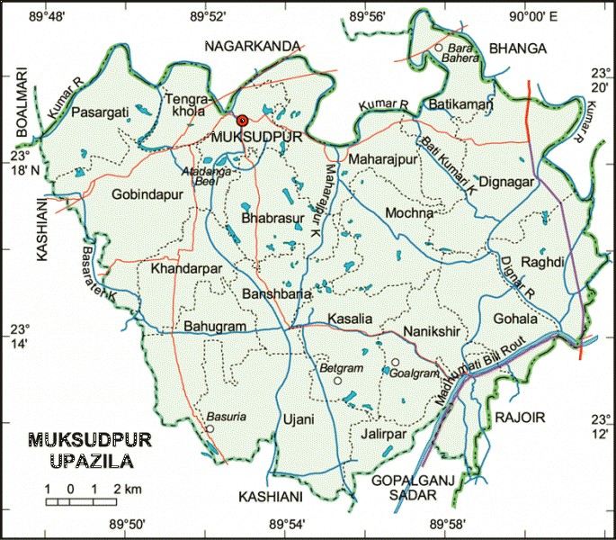
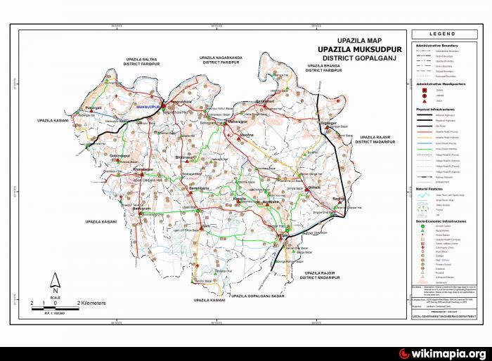
Muksudpur Upazila (Gopalganj district) with an area of 309.63 sq km, is bounded by Nagarkanda and Bhanga upazilas on the north, Gopalganj sadar and Kashiani upazilas on the south, Bhanga and Rajoir upazilas on the east and Kashiani and Boalmari upazilas on the west. Main river is Old Kumar. Madhumati Beel route is an important man made waterway.
The location of Muksudpur town is 23.3181237N 89.8684622E. Muksudpur (Town) a municipal town, consists of 9 wards and 15 mahallas. The area of the town is 2.72 sq km. The town has a population of 18116; male 48.75%, female 51.25%; density of population is 2352 per sq km. Literacy rate among the town people is 57.8%. The town has two dakbungalows.
Muksudpur thana, now an upazila, was established in 1914. It consists of 1 municipality, 17 union parishads, 206 mouzas, 260 villages.
As of the 1991 Bangladesh census: Population 269489; male 50.10%, female 49.90%; Muslim 67.84%, Hindu 30.41%, Christian 1.72%, Buddhist 0.03%.
Religious institutions: Mosque 392, temple 125, church 7.
Literacy and educational institutions: Average literacy 34.3%; male 41.2% and female 27.3%. Educational institutions: college 4, high school 30, junior school 4, madrasa 34, government primary school 128, non-government primary school 57, KG school 4, community school 5, satellite school 10. Noted old institutions: Batikamari Government Primary School (1919), Batikamari High School (1921), SJ High School (1935), Pilot High School (1939), JKMB Mallick High School (1938).
Cultural organisations: Rural club 34, public library 1, cinema hall 1, theatre group 4, women's organisation 8.
Main occupations: Agriculture 43.09%, agricultural labourer 23.45%, wage labourer 2.21%, commerce 10.10%, service 7.69%, fishing 1.71%, industry 1.11%, hawker 2.32%, construction 1.39% and others 6.93%.
Land use: Total cultivable 24256 hectares; fallow land 6664 hectares; cultivable land under irrigation 56%.
Land control: Among the peasants, 18.6% are landless, 55.6% small, 23.3% intermediate and 2.5% rich.
Fisheries, dairies, poultries Poultry 40, fishery 6, dairy 13, hatchery 2.
Communication facilities- Roads: pucca 63.5 km and mud road 138.
Manufactories: Jute mill 1, flour mill 3, ice factory 9, saw mill 14, rice mill 33, oil mill 3, cotton mill 2, dal mill 31.
Cottage industries: Bamboo work 275, goldsmith 66, blacksmith 248, potteries 102, wood work 907, tailoring 825, welding 28.
Mineral resources: Peat coal (Chandar Beel)
NGO activities: Operationally important ngos are brac, proshika, grameen bank, caritas, ccdb, asa, World Vision, HCCB.
Health centres: Upazila health complex 1, family planning centre 13, satellite clinic 6.
Nearby cities:
Coordinates: 23°18'21"N 89°52'10"E
- Abhaynagar Upazila HQ 58 km
- Fakirhat Upazila HQ 59 km
- Kachua Upazila HQ 70 km
- Koyra Upzila HQ 120 km
- Sarishabari Upazila 171 km
- Shaghatta Upazila 219 km
- Gobindaganj Upazila 225 km
- Bholahat Upazila HQ 251 km
- Maidi Vdc 727 km
- Samote Union Council 1958 km
- PROVAKORDI 2.3 km
- LAKHARCHAR 3.2 km
- Munsurabad 13 km
- ajabera 28 km
- Chapada Bill 29 km
- Sripur 36 km
- Charlaxipur by Kalam 37 km
- Khulna Division 71 km
- Dhaka Division 105 km
- TROPIC OF CANCER 918 km