Jibannagar Upazila HQ
Bangladesh /
Chuadanga /
Damurhuda /
World
/ Bangladesh
/ Chuadanga
/ Damurhuda
World / India / West Bengal / North 24 Parganas
township, subdistrict, fourth-level administrative division, local government
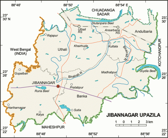
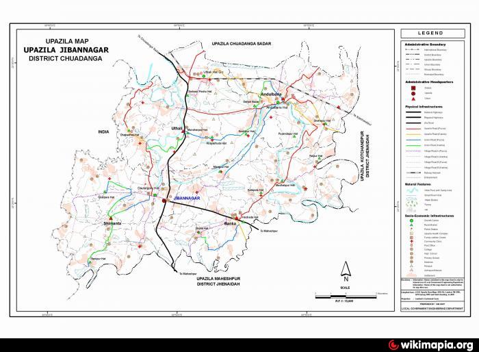
Jibannagar Upazila (Chuadanga district) with an area of 199.32 sq km, is bounded by Chuadanga sadar upazila on the north, Maheshpur upazila on the south, Kotchandpur upazila on the east, West Bengal of India on the west. Main rivers are Bhairab and Kobadak.
The location of the Jibannagar town is 23.4167°N 88.8208°E. Jibannagar (Town) consists of 9 wards and 24 mahallas. It has an area of 15.41 sq km. The town has a population of 25742; male 51.26%, female 48.74%; population density per sq km 1670. Literacy rate among the town people is 26.8%.
Jibannagar thana was turned into an upazila in 1983. The upazila consists of 9 wards, 4 union parishads, 70 mouzas and 89 villages.
Archaeological heritage and relics: Three-domed Mosque at village Dhopakhali.
As of the 1991 Bangladesh census: Population 125102; male 51.32%, female 48.68%; Muslim 95%, Hindu 3.3%, Christian 0.25% and others 1.25%.
Religious institutions: Mosque 70, temple 11.
Literacy and educational institutions: Average literacy 22.4%; male 27.8% and female 16.6%. Educational institutions: college 2, high school 9, junior high school 3, primary school 50, madrasa 18, kindergarten school 1. Noted educational institution: Jibannagar Pilot High School (1957).
Cultural organisations: Rural club 16, public library 1, cinema hall 2, theatre and cultural organisation 5, women's organisation 1.
Main occupations: Agriculture 41.07%, agricultural labourer 33.14%, wage labourer 2.6%, commerce 11.49%, service 3.47%, transport 1.68% and others 6.55%.
Land use: Total cultivable land 15873.58 hectares; single crop 12.47%, double crop 69.58% and treble crop land 17.95%.
Land control: Among the peasants 22.47% are landless, 22.72% marginal, 22.65% small, 18.56% intermediate and 13.06% rich.
Fisheries, dairies, poultries Poultry 25, fishery 4, dairy 3 and hatchery 1.
Communication facilities- Roads: pucca 28.7 km, semi pucca 33.9 km and mud road 276 km; railways 13 km.
Manufactories: Cotton mill, rice mill, flour mill, ice factory, saw mill, welding, etc.
Cottage industries: Weaving, bamboo work, goldsmith, blacksmith, potteries, construction work, bidi and tailoring.
NGO activities: Operationally important NGOs are brac, asa, CARE, WAVE, Usha.
Health centres: Upazila health complex 1, family planning centre 4 and satellite clinic 1.
Nearby cities:
Coordinates: 23°25'45"N 88°49'15"E
- Abhaynagar Upazila HQ 69 km
- Fakirhat Upazila HQ 112 km
- Koyra Upzila HQ 125 km
- Kachua Upazila HQ 135 km
- Bholahat Upazila HQ 182 km
- Sarishabari Upazila 182 km
- Gobindaganj Upazila 205 km
- Shaghatta Upazila 213 km
- Maidi Vdc 646 km
- Samote Union Council 1867 km
- Jibannagar Poura Area 0.6 km
- Ektarpur Lake 5.8 km
- Andul Baria Bazar 10 km
- CAREW & CO.DARSANA. 11 km
- Darsana 12 km
- Boldia 15 km
- HizalGari area 15 km
- Chuadanga District 18 km
- Khulna Division 79 km
- TROPIC OF CANCER 811 km
Comments