Alfadanga Upazila HQ
Bangladesh /
Naral /
World
/ Bangladesh
/ Naral
/ Naral
World / Bangladesh / Dhaka / Faridpur / Faridpur
township, subdistrict, fourth-level administrative division, local government
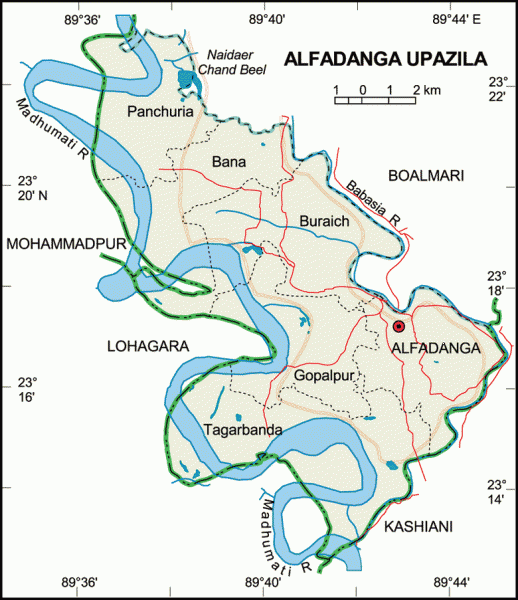
Alfadanga Upazila (Faridpur district) with an area of 136 sq km, is bounded by Boalmari upazila on the northeast, Kashiani upazila on the south, Mohammadpur and Lohagara upazila on the west. Madhumati is the main river.
The location of Alfadanga town is 23.2973047N 89.700239E. Alfadanga Town consists of 2 mouzas with an area of 4.39 sq km. It has a population of 4796; male 51.06%, female 48.94%. Population density in the town is 1092 per sq km. Literacy rate among the town people is 39.2%.
Alfadanga thana, now an Upazila, was established in 1960. The upazila consists of 6 union parishads, mouza 86 and 124 villages.
As of the 1991 Bangladesh census: Population 90873; male 49.83%, female 50.17%; Muslim 90.18%; Hindu 9.73%, Christian 0.02%, Buddhist 0.02% and others 0.05%.
Literacy and educational institutions Average literacy 32.05%; male 38.8%, female 26.04%. Educational institutions: College 2, high school 12, madrasha 10, government primary school 40, non-government primary school 15.
Cultural orgnisations: Rural club 30, cinema hall 1, women's organisation 17, playground 18 and officers' club 1.
Religious institutions: Mosque 144, temple 15, tomb 2 most noted of which is tomb of Bedan Shah (R)
Main occupations: Agriculture 39.04%, fishing 1.66%, agricultural labourer 21.69%, wage labourer 1.81%, commerce 9.67%, transport 2.02%, service 13.62%, others 9.89%.
Land use: Total land under cultivation 8891.14 hectares; single crop 35%, double crop 57% and treble crop land 8%; land under irrigation 2035.61 hectares.
Land control: Among the peasants 38% are landless, 32% small, 25% intermediate and 5% rich; cultivable land per head 0.1 hectare.
Poultries Poultry farm 17.
Communication facilities- Roads: pucca 25.31 km, semi-pucca 11 km, mud 139.44 km; waterways 95 km.
Manufactories: Ice factory 1, saw mill 6, ball pen factory 1.
Cottage industries: Bamboo works 15, goldsmiths 22, blacksmiths 45, potters 10, wood works 40, tailoring 120, welding 8.
NGO activities: Operationally important NGOs are brac, PIP and SDC.
Health centres: Upazila health complex 1, satellite clinic 4, family planning centre 3, BRAC health centre 1.
Nearby cities:
Coordinates: 23°17'12"N 89°41'54"E
- Abhaynagar Upazila HQ 42 km
- Fakirhat Upazila HQ 54 km
- Kachua Upazila HQ 70 km
- Koyra Upzila HQ 110 km
- Sarishabari Upazila 172 km
- Shaghatta Upazila 219 km
- Gobindaganj Upazila 223 km
- Bholahat Upazila HQ 241 km
- Maidi Vdc 716 km
- Samote Union Council 1946 km
- PROVAKORDI 16 km
- LAKHARCHAR 17 km
- Chapada Bill 21 km
- Munsurabad 28 km
- ajabera 29 km
- Sripur 31 km
- Charlaxipur by Kalam 32 km
- Khulna Division 57 km
- Dhaka Division 116 km
- TROPIC OF CANCER 901 km