Durgapur Upazila HQ
Bangladesh /
Nator /
World
/ Bangladesh
/ Nator
/ Nator
World / Bangladesh / Rajshahi / Rajshahi / Rajshahi
township, subdistrict, fourth-level administrative division, local government
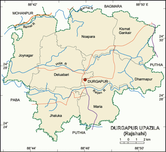
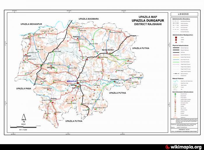
Durgapur Upazila (Rajshahi district) with an area of 195.03 sq km, is bounded by Bagmara and Mohanpur upazilas on the north, Puthia upazila on the south and east, Paba upazila on the west. Hoja and Raijan rivers are almost dead.
The location of the Durgapur town is 24.513608N 88.8504708E. Durgapur (Town) consists of three mouzas. The area of the town is 4.35 sq km. It has a population of 4197; male 52.30%, female 47.70%. Population density per sq km is 965. Literacy rate among the town people is 38.1%. The town has one dakbungalow.
Durgapur thana was established in 1909 and was turned into an upazila in 1984. It consists of seven union parishads, 114 mouzas and 122 villages.
Archeological heritage and relics: Two domed Kismat Mosque at Madia (eighteen century), one domed Ruipara Jami Mosque (sixteen century)
As of the 1991 Bangladesh census: Population 137640; male 51%, female 49%; Muslim 96.62%, Hindu 3.08%, Christian 0.23%; ethnic nationals: Santal 108 families.
Religious institutions: Mosque 338, temple 14, church 1, sacred place 1.
Literacy and educational institutions: Average literacy 20.2%; male 27.5% and female 12.6%. Educational institutions: college 9, secondary school 28, madrasa 10, government primary school 45, non-government primary school 32. Noted educational institutions: Sreedhar Government Primary School (1857), Singa Government Primary School (1923), Daudkandi High school (1946).
Cultural organisations: Rural club 20, public library 1, theatre group 1, cinema hall 1, women's organisation 1 and playground 26.
Main occupations: Agriculture 52.76%, agricultural labourer 29.75%, wage labourer 1.7%, commerce 6.16%, service 2.2% and others 7.43%.
Land use: Total cultivable land 19877.78 hectares; fallow land 178.54 hectares; single crop 40%, double crop 41% and treble crop 19%; cultivable land under irrigation 85%.
Land control: Among the peasants 34% are landless, 28% small, 26 intermediate and 12% rich; cultivable land per head 0.15 hectare.
Fisheries, dairies, poultries Poultry 11, fishery 44, hatchery 7.
Communication facilities- Roads: pucca 42 km, semi pucca 14 km and mud road 575 km.
Manufactories: Flour mill 1, rice mill 10, saw mill 4, press 2, ice factory 7, welding 11.
Cottage industries: Weaving 12, bamboo work 274, goldsmith 37, blacksmith 74, potteries 510, wood work 140, tailoring 270 and bidi 1; cocoon produced by female labourers.
NGO activities: Operationally important NGOs are brac, asa, caritas, thengamara mahila sabuj sangha, Barendra.
Health centres: Upazila health complex 1, family planning centre 7 and satellite clinic 2.
Nearby cities:
Coordinates: 24°30'54"N 88°50'55"E
- Bholahat Upazila HQ 83 km
- Gobindaganj Upazila 88 km
- Sarishabari Upazila 96 km
- Shaghatta Upazila 103 km
- Abhaynagar Upazila HQ 170 km
- Fakirhat Upazila HQ 209 km
- Kachua Upazila HQ 229 km
- Koyra Upzila HQ 241 km
- Maidi Vdc 558 km
- Samote Union Council 1794 km
- Jagadishpur 7.5 km
- Refueling Station 16 km
- Refueling Station 16 km
- Bridge 16 km
- Puthia P.N Model High School 16 km
- Puthiya Girl's High School 16 km
- Puthia Upazila Health Complex 16 km
- Cold Storage 17 km
- shib pur bazaar 17 km
- Rajshahi Division 79 km