Chowgacha Upazila HQ
Bangladesh /
Jhanaydah /
Kotchandpur /
World
/ Bangladesh
/ Jhanaydah
/ Kotchandpur
World / Bangladesh / Khulna / Jessore / Jessore
township, subdistrict, fourth-level administrative division, local government
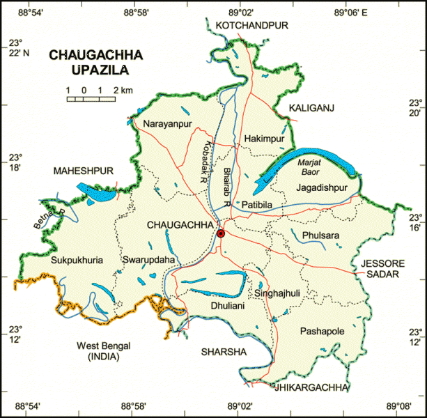

Chaugachha Upazila (Jessore district) with an area of 280.39 sq km, is bounded by Maheshpur, Kotchandpur and Kaliganj (Jhenaidaha) upazilas on the north, 24 Pargana of West Bengal (India), Sharsha and Jhikargachha upazilas on the south, Kaliganj and jessore sadar upazilas on the east, Maheshpur upazila on the west. Main rivers are Kobadak, Betna and Bhairab; baor 8.
Chowgacha is located at 23.2667°N 89.0250°E. Chaugachha (Town) consists of 4 mouzas. The area of the town is 7.87 sq km. The town has a population of 9835; male 52.14%, female 47.86%. It has 33765 units of house hold and total area 268.89 km². Literacy rate among the town people is 37%. The town has one dakbungalow.
Chaugachha thana was turned into an upazila in 1983. It consists of 11 union parishads, 150 mouzas and 166 villages.
Archaeological heritage and relics: Neelkuthi.
As of the 1991 Bangladesh census: Population 181829; male 51.60%, female 48.40%; Muslim 91.66%, Hindu 8.24% and others 0.1%; ethnic nationals: Santal 103 families.
Religious institutions: Mosque 248, temple 181 and sacred place 1.
Literacy and educational institutions: Average literacy 25.3%; male 32.7% and female 17.8%. Educational institutions: college 3, high school 33, madrasa 17, government primary school 61, non-government primary school 59, community primary school 13. Notable old educational institutions: Narayanpur High School and Chaugachha High School.
Cultural organisations: Club 4, library 1, theatre group 1, cinema hall 1, literary society 1.
Main occupations: Agriculture 48.38%, agricultural labourer 27.53%, wage labourer 2.20%, commerce 8.37%, service 3.06%, fishing 1.08%, industry 1.29%, transport 2% and others 6.09%.
Land use: Total cultivable land 18069.6 hectares; fallow land 1156.21 hectares; single crop 10.59%, double crop 69.81% and treble crop 19.60%.
Land control: Among the peasants 17.72% are landless, 55.26% small, 22.17% intermediate and 4.85% rich; cultivable land per head 0.09 hectare.
Fisheries, dairies, poultries Poultry 199, dairy 20, hatchery 3 and fishery 20.
Communication facilities- Roads: pucca 37.54 km, semi pucca 10 km and mud road 283.45 km; waterways 7 nautical mile.
Manufactories: Ginning mill 2, ice factory 2.
Cottage industries: Weaving 15, bamboo work 30, goldsmith 25, blacksmith 22, potteries 15, wood work 31, tailoring 45, brick field 9 and welding 26.
NGO activities: Operationally important NGOs are Bela, Apan, brac, asa and Dhaka Ahasania Mission.
Health centres: Upazila health complex 1, family planning centre 11, satellite clinic 3.
Nearby cities:
Coordinates: 23°15'55"N 89°1'15"E
- Abhaynagar Upazila HQ 42 km
- Fakirhat Upazila HQ 85 km
- Koyra Upzila HQ 101 km
- Kachua Upazila HQ 108 km
- Sarishabari Upazila 189 km
- Bholahat Upazila HQ 207 km
- Gobindaganj Upazila 220 km
- Shaghatta Upazila 225 km
- Maidi Vdc 673 km
- Samote Union Council 1894 km
- long lake 6.6 km
- Historical 12 Aolia (saint) 11 Ponds and 10 Masjid's 14 km
- ullah, kaligonj, jhenidah 26 km
- BAMONYLE 33 km
- BAMONYLE 33 km
- BAMONYLE 33 km
- Jhenaidah District Town 35 km
- Chuadanga District 42 km
- Khulna Division 52 km
- TROPIC OF CANCER 832 km