Dacope Upazila HQ
Bangladesh /
Khulna /
Phultala /
World
/ Bangladesh
/ Khulna
/ Phultala
World / Bangladesh / Barisal / Barisal / Pirojpur
township, subdistrict, fourth-level administrative division, local government
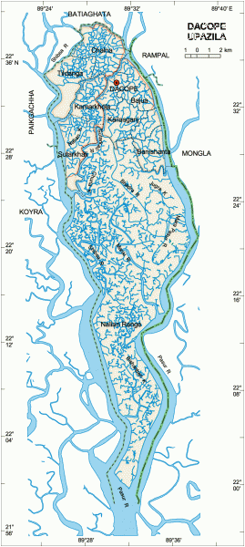

Dacope Upazila (Khulna district) with an area of 99158 sq km, is bounded by Batiaghata upazila on the north, Pashur river on the south, Rampal and Mongla upazilas on the east, Paikgachha and Koyra upazilas on the west. Main rivers are Pasur, Sibsa, Manki, Bhadra. The southern part of this upazila is surrounded by Sundarban (11790.13 hectors).
The location of the Dacope town is 22.6000757N 89.517535E. Dacope (Town) consists of one mouza with an area of 22 sq km. It has a population of 16552; male 52.31%, female 47.69%. The density of population is 752 per sq km. Literacy rate among the town people is 42.2%.
Dacope thana was established in 1913 and was turned into an upazila in 1983. It consists of 10 union parishads, 26 mouzas, 107 villages.
As of the 1991 Bangladesh census: Population 143131; male 52.25%, female 47.75%; Muslim 37%, Hindu 61%, Christian 1%, ethnic and others 1%.
Religious institutions: Mosque 72, temple 137, church 11, pilgrimage 2.
Literacy and educational institutions: Average literacy 37.6%; male 47.8% and female 26.4%. Educational institutions: college 4, high school 31, government primary school 51, non-government primary school 56, madrasa 4. Noted Educational institutions: Sreenagar M E High School (1817), Bazua Union High School (1920), Chalna government K C Primary School (1947), Dacope Sahaber Abad High School (1947) and Bazua government Primary School (1947).
Cultural organisations: Club 40, public library 2, theatre group 1, opera party 1, women's organisation 1.
Main occupations: Agriculture 46.95%, fishing 2.38%, piciculture 2%, agricultural labourer 17.26%, wage labourer 4.84%, commerce 9.48%, service 3.44%, others 13.65%.
Land use: Total cultivable land 28544.4 hectares; single crop 92.92%, double crop 7.08%.
Land control: Among the peasants 20% are landless, 30% small, 35% intermediate, 15% rich; cultivable land per head 0.19 hectare.
Fisheries, dairies, poultries fishery 1565, golda prawn 65, bagda 1500, poultry 154.
Communication facilities- Roads: pucca 11 km, semi pucca 43 km, mud road 307 km; waterways 57 nautical mile.
Manufactories: Fish processing factory 2, Sugar mill 1, Rice mill 5, Salt production centre 1.
Cottage industries: Bamboo and cane work 10, iron mill 32, goldsmith 45.
NGO activities: Operationally important NGOs are BRAC, Proshika, World Vision, Gonoshahajjo Sangstha, HEED Bangladesh, Step, Prodipon.
Health centres: Hospital 1, Family welfare centre 3, Health and Family Planning Centre 5, Maternity and Child Health Cente 1.
Nearby cities:
Coordinates: 22°35'59"N 89°30'45"E
- Fakirhat Upazila HQ 28 km
- Koyra Upzila HQ 35 km
- Kachua Upazila HQ 36 km
- Abhaynagar Upazila HQ 54 km
- Sarishabari Upazila 250 km
- Shaghatta Upazila 294 km
- Gobindaganj Upazila 295 km
- Bholahat Upazila HQ 295 km
- Maidi Vdc 762 km
- Samote Union Council 1981 km
- Rampal Thermal Power Plant site 4.7 km
- Shalidanga Village 8.7 km
- SUBODHA GRAME 10 km
- TEKATIA GARAM 14 km
- Betaga Union, sadar, bagerhat. 15 km
- Airstrip 15 km
- Jalmaa(Hirak Dhali) 16 km
- Batiaghata Bazar 16 km
- Chhyoghoria 18 km
- Khulna Division 38 km