Chandina Upazila HQ
Bangladesh /
Komilla /
World
/ Bangladesh
/ Komilla
/ Komilla
World / Bangladesh / Chittagong / Comilla / Comilla
township, subdistrict, fourth-level administrative division, local government
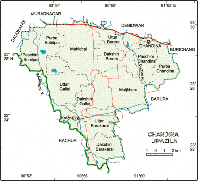
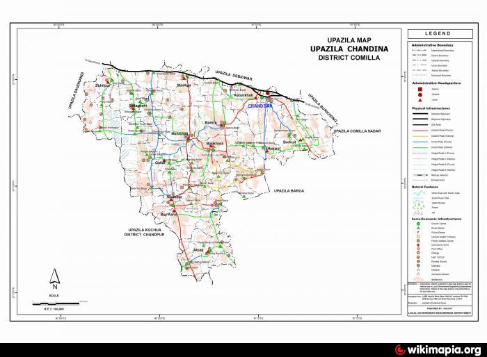
Chandina Upazila (Comilla district) with an area of 202.98 sq km, is bounded by Daudkandi, Muradnagar and Debidwar upazilas on the north, Barura and Kachua upazilas on the south, Burichang and Barura upazilas on the east, Daudkandi and Kachua upazilas on the west. Main river is Kalichari. Ghogra Beel is notable.
The location of the Chandina town is 23.4881339N 91.0080586E. Chandina (Town) consists of Chandina, Maharang, Belashahar and part of Rarir Char. The town is now a municipality with an area of 4.27 sq km and population 35601; male 50.63%, female 49.37%. It has 9 words and 19 mahallas. Literacy rate among the town people is 38.7 %. It has five dakbungalows.
Chandina thana was turned into an upazila in 1983. The upazila consists of one municipality, 12 union parishads, 126 mouzas and 232 villages.
As of the 1991 Bangladesh census: Population 269878; male 50.18%, female 49.82%; Muslim 91.53%, Hindu 8.35%, Christian 0.03%, Buddhist 0.03% and others 0.06%.
Religious institutions: Mosque 375, temple 18, tomb 1,
Literacy and educational institutions: Average literacy 27.7%; male 34.3%, female 21.1%. Educational institutions: college 6, high school 36, junior high school 2, madrasa 96, government primary school 86, non-government primary school 20, satellite school 10, low cost school 9, maktab 175 and orphanage 4. Noted educational institutions: Chandina Pilot High School (1916), Bishwas Government Primary School (1916), Bakarhat Government Primary School (1939), Chandina Model Government Primary School (1940), West Belashahor Government Primary School (1935), Madhaiya Government Primary School (1930).
Cultural organisations: Club 52, public library 3, cinema hall 1, theatre stage 1.
Main occupations: Agriculture 50.45%, agricultural labourer 21.07%, commerce 9.3%, service 5.95%, transport 2.95%, wage labourer 2.34% and others 7.84%.
Land use: Total land 20202.35 hectares, cultivable land 15831.65 hectares, fallow land 4370.70 hectares, khas land 704.69 hectares; single crop 10%, double crop 61%, treble crop 29%.
Land control: Among the peasants 22.17% are landless, 30.12% marginal, 37.35% small, 31.78% intermediate and 1.76% rich; cultivable land per head 0.06 hectare.
Fisheries, dairies, poultries Fishery 2, dairy 16, poultry 107 and hatchery 5.
Communication facilities- Roads: pucca 41 km, semi pucca 1.5 km, mud road 398 km.
Manufactories: Textile mill 1, flour mill 2 and cold storage 3.
Cottage industries: Weaving 200, bamboo work 28, blacksmith 9, wood work 15, potteries 9, goldsmith 30, tailoring 41.
NGO activities: Operationally important NGOs are brac, asa, grameen bank, proshika, Pages, Samabaya, Disha, nijera kari, Grameen Karma Bikash and Mahila Shilpa Uddakta Unnayan Karmasuchi.
Health centres: Upazila health complex 1, sub health centre 1, family planning centre 12.
Nearby cities:
Coordinates: 23°29'18"N 91°0'34"E
- Matlab Upazila (North) Area 45 km
- Rupganj Upazila 70 km
- Lohajang Upazila 80 km
- Keraniganj Upazila 83 km
- Kapashia Upazila 102 km
- Gafargaon Upazila 130 km
- Patiya Upazila (পটিয়া) 150 km
- Chandanaish Upazila 165 km
- Banshkhali Upazila (বাঁশখালী উপজেলা) 169 km
- Dhobaura Upazila 202 km
- Barkamta/Badkamta 1.1 km
- hospital 9 km
- সাহারপাড়/Shaharpar 10 km
- union 20 18 km
- KakairTala 20 km
- Daudkandi Bazaar 30 km
- Vill. : East Islamabad (AZAD, BUET, PWD) 31 km
- Haziganj 31 km
- Chandpur District Town 45 km
- TROPIC OF CANCER 1034 km