Burichong Upazila HQ
| township, subdistrict, fourth-level administrative division, local government
Bangladesh /
Komilla /
World
/ Bangladesh
/ Komilla
/ Komilla
World / Bangladesh / Chittagong / Comilla / Comilla
township, subdistrict, fourth-level administrative division, local government
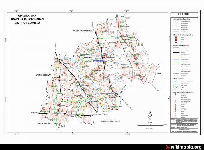
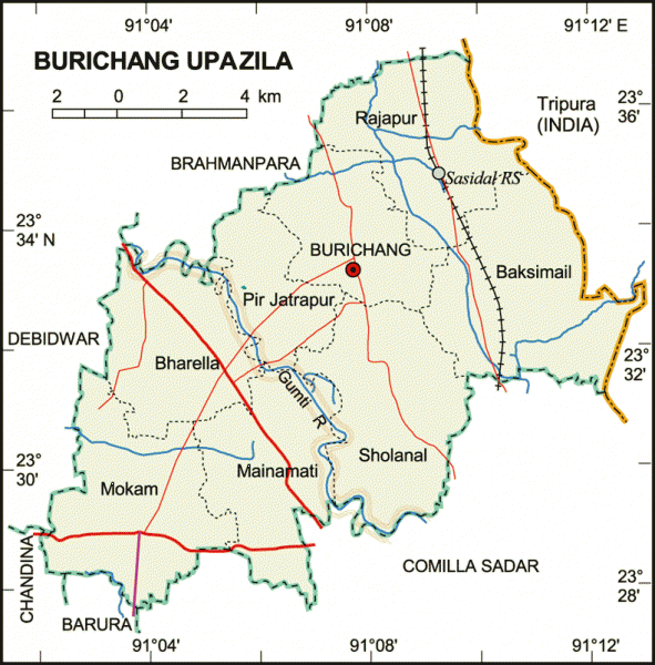
Burichong (Bengali: বুড়িচং) is an Upazila of Comilla District in the Division of Chittagong, Bangladesh. Burichang Upazila with an area of 163.76 square km is bounded by Brahman Baria upazila in the north, Comilla Sadar Upazila and Barura in the south, Debidwar and Chandina upazilas in West and Tripura state of India in the east.
Burichong is located at 23.5500°N 91.1264°E. It has 37739 units of house hold and total area 163.76 km².Important unions and places: There are 11 unions in Burichang upazila. Rajapur, Baksimal, Bharella, Sholanal, Mokam etc. are the important place of Burichang.
As of the 1991 Bangladesh census, Burichong has a population of 228479. Males constitute are 51.68% of the population, and females 48.32%. This Upazila's eighteen up population is 106787. Burichong has an average literacy rate of 34.3% (7+ years), and the national average of 32.4% literate.
Burichong has 8 Unions/Wards, 152 Mauzas/Mahallas, and 171 villages.
Historical or Tourist Places: Many archaeological relics including image of Buddha, terracotta plucks and Buddhist relics have been discovered.
School/College: Fakir Bazar High School (1943), Burichang Ananda Pilot High School (1925), Kharataiya High School (1982), Mithilapur Government Primary School (1908) and Sreepur Senior Fazil Madrasa (1932) etc are famous educational institution of Burichang.
Hotel Motel: There are some residential hotel in Burichang.
Travel from Dhaka: There are available bus from Dhaka to Burichang. You may have to go Comilla first and then Burichang.
Nearby cities:
Coordinates: 23°32'52"N 91°7'48"E
- Matlab Upazila (North) Area 57 km
- Rupganj Upazila 75 km
- Lohajang Upazila 92 km
- Keraniganj Upazila 93 km
- Kapashia Upazila 104 km
- Gafargaon Upazila 130 km
- Patiya Upazila (পটিয়া) 149 km
- Chandanaish Upazila 164 km
- Banshkhali Upazila (বাঁশখালী উপজেলা) 169 km
- Dhobaura Upazila 200 km
- BURICHONG BAZAR 0.7 km
- BURICHONG HOSPITAL 1.1 km
- (Manigarchore Bazar) 2.1 km
- Methalapur 6.1 km
- Rani Kuthir - Mainamoti 6.2 km
- BALIKHARA VILLAGE 6.6 km
- Mainamati War Cemetery 7.1 km
- CMH Comilla Cantt. 7.4 km
- Hospital Block 7.5 km
- Comilla Cantonment 10 km