Kotchandpur Upazila HQ
Bangladesh /
Jhanaydah /
Kotchandpur /
World
/ Bangladesh
/ Jhanaydah
/ Kotchandpur
World / Bangladesh / Khulna / Jessore / Jhenaidah
township, fourth-level administrative division, local government
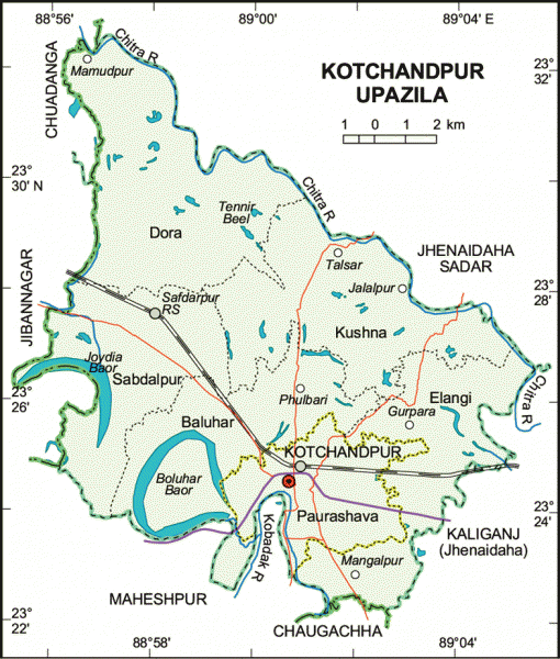
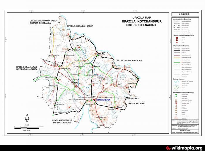
Kotchandpur Upazila (Jhenaidah district) with an area of 165.66 sq km, is bounded by Jhenaidah sadar upazila on the north, Maheshpur and Chaugachha upazilas on the south, Kaliganj (Jhenaidah) upazila on the east, Chuadanga sadar and Jibannagar upazilas on the west. Main rivers are Chitra and Kobadak; Buror Beel and Baluhar Baor are notable.
The location of Kotchandpur town is 23.4132379N 89.0162226E. Kotchandpur (Town) municipality was establised in 1883. It consists of 9 wards and 43 mahallas. The area of the town is 17.85 sq km. The town has a population of 32217; male 51.41%, female 48.49%. Literacy rate among the town people is 41.5%.
Kotchandpur thana was established in 1883 and was turned into an upazila in 1983. The upazila consists of one municipality, 5 union parishads, 114 mouzas and 79 villages.
Archaeological heritage and relics: Chand Khan Mazar (1656), Shivabari Mandir (1680), Mohila College Building (1805), Jami Mosque (1884) at village Nagda, Jami Mosque (1885) at Barabamandaha.
As of the 1991 Bangladesh census, population 107193; male 51.4%, female 48.6%; Muslim 88.29%, Hindu 11.70% and others 0.01%.
Religious institutions: Mosque 252, temple 20 and tomb 3.
Literacy and educational institutions: Average literacy 26.9%; male 33.4% and female 19.9%. Educational institutions: college 3, high school 9, junior high school 2, madrasa 11, government primary school 37, non-government primary school 29, kindergarten school 2. Noted educational institutions: Kotchandpur Pilot High School (1899), Kotchandpur Degree College (1969).
Cultural organisations: Club 23, public library 1, community centre 5, press club 2, cooperative society 171, business society 1 and welfare society 1.
Main occupations: Agriculture 42.59%, agricultural labourer 25.20%, wage labourer 3.02%, commerce 11.97%, service 4.95% and others 12.27%.
Land use: Total cultivable land 17734 hectares; khas land 62.81 hectares, fallow land 28.33 hectares; single crop 34.32%, double crop 56.27% and treble crop 9.41%, cultivable land under irrigation 63%.
Land control: Among the peasants 30% are landless, 33% small, 27% intermediate and 10% rich; cultivable land per head 0.10 hectare.
Main crops: Paddy, jute, wheat, sugarcane and vegetables.
Fisheries, dairies, poultries Dairy 15, poultry 12, fishery 867, hatchery 30 and artificial cattle breeding centre 1.
Communication facilities- Roads: pucca 73 km, mud road 474 km; railways 15.82 km.
Manufactories: Rice mill 14, saw mill 10, welding 9 and candy factory 2.
Cottage industries: Potteries 10, goldsmith 32, wood work 30, tailoring 154, brass work 2 and wheel making (bullock cart) 2.
NGO activities: Operationally important NGOs are brac, asa, grameen bank and RICO.
Health centres: Upazila health complex 1, family welfare centre 2, maternity and child welfare centre 3, private clinic 1 and veterinary hospital 1.
Nearby cities:
Coordinates: 23°25'0"N 89°0'30"E
- Abhaynagar Upazila HQ 54 km
- Fakirhat Upazila HQ 97 km
- Koyra Upzila HQ 118 km
- Kachua Upazila HQ 120 km
- Sarishabari Upazila 174 km
- Bholahat Upazila HQ 191 km
- Gobindaganj Upazila 203 km
- Shaghatta Upazila 209 km
- Maidi Vdc 659 km
- Samote Union Council 1882 km
- long lake 15 km
- Historical 12 Aolia (saint) 11 Ponds and 10 Masjid's 19 km
- ullah, kaligonj, jhenidah 21 km
- Jhenaidah District Town 22 km
- BAMONYLE 27 km
- BAMONYLE 27 km
- BAMONYLE 27 km
- Chuadanga District 28 km
- Khulna Division 66 km
- TROPIC OF CANCER 830 km