Trishal Upazila HQ
Bangladesh /
Maimansingh /
World
/ Bangladesh
/ Maimansingh
/ Maimansingh
World / Bangladesh / Dhaka / Mymensingh / Nasirabad
township, subdistrict, fourth-level administrative division, local government

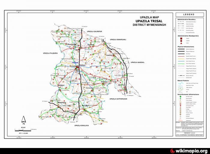
Trishal Upazila (Mymensingh district) with an area of 338.98 sq km, is bounded by Mymensingh sadar upazila on the north, Bhaluka and Gafargaon upazilas on the south, Ishwarganj, Nandail and Gaffargaon upazilas on the east, Fulbaria upazila on the west. Main rivers are Old Bhramaputra, Khiru, Sutia, Meduari, Nageshwari, Pagria and Barera; notable depressions: Beel Galhar, Shukni, Singaduli, Durbachora and Kumuria. The famous Bengali poet Kazi Nazrul Islam attended a school here.
Trishal is located at 24.5792742N 90.3950388E. Trishal (Town) consists 9 wards and 11 mahallas. The area of the town is 25.39 sq km. It has a population of 24306; male 52.41%, female 47.59%; density of population is 957 per sq km. The literacy rate among the town people is 33.5%. It has a dakbungalow.
Trishal thana was established in 1909 and was turned into an upazila in 1983. The upazila consists of 12 union parishads, 91 mouzas, 160 villages.
Archaeological relics and heritage: Single-domed Jami mosque at Darirampur (Mughal period).
As of Bangladesh census, population 336797; male 52.36%, female 47.64%; Muslim 96.58%, Hindu 3.12%, Christian 0.15% and ethnic nationals 0.15%.
Religious institutions Mosque 421, temple 35, place of pilgrimage 2 and tomb 3.
Average literacy 25.2%: male 29.7% and female 20.4%. Educational institutions: university 1, college 3, technical college 1, high school 31, junior high school 6, vocational school 1, madrasa 170, government primary school 120, non-government primary school 42, community school 10, satellite school 10, kindergarten 5. Noted educational institutions are Nazrul College (1967), Trishal Mohila College (1990), Trishal Abbasia Senior Madrasa (1931), Darirampur High School 1913 (Nazrul Academy).
Cultural organisations Club 90, library 10, playground 21, cinema hall 4 and women's organisation 1.
Main occupations Agriculture 52.69%, forestry and fishing 1.12%, agricultural labourer 20.06%, wage labourer 2.78%, commerce 9.99%, service 3.54%, others 9.87%.
Land use: Total cultivable land 23576.49 hectares, fallow land 978.35 hectares; single crop 8.6%, double crop 86% and treble crop land 17.5%; land under irrigation 52.8%.
Manufactories Rice mill 37, ice factory 29, saw mill 25, biscuit factory 5 and bidi factory 1.
Cottage industries Weaving 78, goldsmith 65, wood work 205, welding 30, bamboo work 290, potteries 58, ghani 666, lathe machine 8 and bidi 3.
Fisheries, dairies, poultries Fishery 7, live stock 12, dairy 5, poultry 89 and hatchery 1.
Communication facilities: Roads: pucca 22.92 km and mud road 644; railway 16.25 km; waterways 16 nautical mile
Health centres Upazila health complex 1, satellite clinic 4, family planning centre 2.
NGO activities Operationally important NGOs are brac, asa, grameen bank, ITCL, Delta Nayan Foundation, Palli Unnayan Academy, Shoshi Foundation.
Nearby cities:
Coordinates: 24°34'50"N 90°23'30"E
- Gafargaon Upazila 7.6 km
- Kapashia Upazila 36 km
- Dhobaura Upazila 69 km
- Rupganj Upazila 71 km
- Keraniganj Upazila 93 km
- Lohajang Upazila 117 km
- Matlab Upazila (North) Area 121 km
- Patiya Upazila (পটিয়া) 286 km
- Chandanaish Upazila 301 km
- Banshkhali Upazila (বাঁশখালী উপজেলা) 306 km
- Kazir Simla, Trishal 9 km
- kadam rasulpur 9 km
- Fatema Nogor 9 km
- South Balipara 13 km
- chormadakhali 14 km
- Bangladesh Agricultural University (BAU) 17 km
- Momenshahi Cantonment 19 km
- Atpara Upazila 46 km
- Dhaka Division 49 km
- Netrakona Sadar Upazila 50 km