Phulbari Upazila HQ
Bangladesh /
Lalmanir Hat /
World
/ Bangladesh
/ Lalmanir Hat
/ Lalmanir Hat
World / Bangladesh / Rajshahi / Ranpur / Kurigram
township, subdistrict, fourth-level administrative division, local government
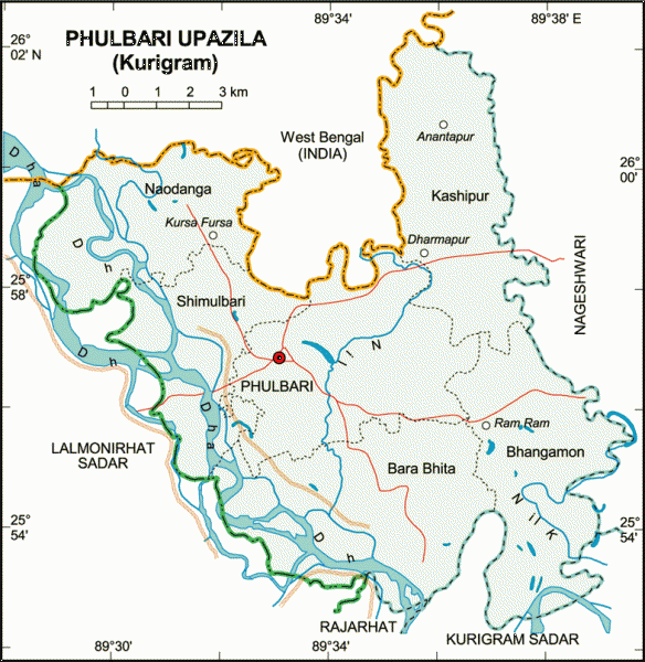

Phulbari Upazila (Kurigram district) with an area of 163.63 sq km, is bounded by West Bengal of India on the north, Kurigram sadar, Rajarhat and Lalmonirhat sadar upazilas on the south, Nageshwari upazila on the east and Lalmonirhat Sadar upazila on the west. Main rivers are Dharla and Nilkamol.
Phulbari is located at 25.9500°N 89.5667°E. It has 25236 units of house hold. Phulbari (Town) consists of one mouzas. It has an area of 8.74 sq km. The town has a population of 9775; male 50.13% and female 49.87%; population density per sq km 1118. Literacy rate among the town people is 26.7%. The town has one dakbungalow.
Phulbari thana, now an upazila, was established in 1914. The upazila consists of 6 union parishads, 50 mouzas, 165 villages and 3 enclaves.
As of the 1991 Bangladesh census, Population 129668: male 50.49%, female 49.51%; Muslim 87.7%, Hindu 11.8% and others 0.5%.
Religious institutions Mosque 261 and temple 11.
Average literacy 24%: male 33% and female 18.8%. Educational institutions: Degree college 1, intermediate college 4, high school 24, madrasa 12, government primary school 54, non-government primary school 75, kindergarten 1. Noted educational institutions: Naodanga High School (1919) and Jasimia High School (1938).
Main occupations Agriculture 45.86%, agricultural labourer 31.65%, wage labourer 4.46%, commerce 6.78%, service 2.60% and others 8.65%.
Land use Total cultivable land 13266.29 hectares, fallow land 222.58 hectares; single crop 12%, double crop 77% and treble crop land 11%. Cultivable land under irrigation 19%.
Land control Among the peasants, 45% are landless, 30% small, 18% intermediate and 7% rich; cultivable land per head 0.05 hectare.
Manufactories: Rice mill 7, flour mill 2, welding 3, ice factory 3.
Cottage industries: Bamboo work 20, goldsmith 12, blacksmith 15, potteries 25, wood work 30, tailoring 35.
Communication facilities Roads: pucca 15 km, semi pucca 11 km and mud road 675 km; waterways 2 nautical mile.
Health centres Upazila health complex 1, family planning clinic 5.
NGO activities Operationally important NGOs are brac, RDRS, Chhinnamukul, Solidarity, etc.
Nearby cities:
Coordinates: 25°56'44"N 89°33'29"E
- Shaghatta Upazila 79 km
- Gobindaganj Upazila 87 km
- Sarishabari Upazila 125 km
- Bholahat Upazila HQ 176 km
- Abhaynagar Upazila HQ 321 km
- Fakirhat Upazila HQ 350 km
- Kachua Upazila HQ 365 km
- Koyra Upzila HQ 398 km
- Maidi Vdc 526 km
- Samote Union Council 1762 km
- Sonar Chhara 7.2 km
- briabari up azila 10 km
- NEW GITALDAHA [ADDED BY TINKU] 13 km
- Poaturkuthi Enclave, Study Area of Dulon Sarkar , MA in Geography , VISVA-BHARATI 13 km
- Former Lalmonirhat Air Base [Earlier, used in the 2nd World War] 15 km
- Kurigram District 23 km
- sitai 29 km
- Lalmonirhat District 38 km
- Rangpur District 49 km
- Rajshahi Division 101 km